IMAGES TAKEN NEAR TO
Kingsleane, LEOMINSTER, HR6 9SP
Introduction
This page details the photographs taken nearby to Kingsleane, HR6 9SP by members of the Geograph project.
The Geograph project started in 2005 with the aim of publishing, organising and preserving representative images for every square kilometre of Great Britain, Ireland and the Isle of Man.

There are currently over 7.5m images from over14,400 individuals and you can help contribute to the project by visiting https://www.geograph.org.uk
Image Map
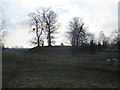
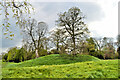
Images are licensed for reuse under creativecommons.org/licenses/by-sa/2.0
Notes
- Clicking on the map will re-center to the selected point.
- The higher the marker number, the further away the image location is from the centre of the postcode.
Image Listing (165 Images Found)
Images are licensed for reuse under creativecommons.org/licenses/by-sa/2.0
Image
Details
Distance
1
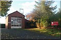
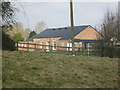
Kingsland fire station
Kingsland fire station, Arbour Lane, Kingsland, Herefordshire, forms part of the Hereford & Worcester Fire & Rescue Service.
Image: © Kevin Hale
Taken: 21 Oct 2006
0.05 miles
2
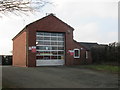
Kingsland Fire Station
Here is the fire station at Kingsland. The village first had its fire station around 1893, and was placed somewhere else back then.
Image: © Fabian Musto
Taken: 24 Feb 2018
0.07 miles
3
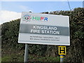
Sign at Kingsland Fire Station
This sign shows that this fire station at Kingsland is part of the "Hereford & Worcester Fire and Rescue Service" group.
Image: © Fabian Musto
Taken: 24 Feb 2018
0.07 miles
4
Kingsland Fire Station
Here is the back side of Kingsland Fire Station, viewed from a public footpath leading onto the A4110 road.
Image: © Fabian Musto
Taken: 24 Feb 2018
0.07 miles
5
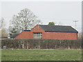
Kingsland Village Hall (Viewed from Kingsland Castle)
Here is Kingsland Village Hall, viewed from the earthworks of Kingsland Castle.
Image: © Fabian Musto
Taken: 24 Feb 2018
0.08 miles
6
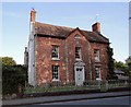
A 'nice modest early c18 brick house of three bays', Kingsland
Minor architectural gem just off the main street. Pevsner's description says it all, as is always the case.
Image: © Philip Pankhurst
Taken: 27 Jun 2010
0.10 miles
7
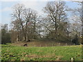
Kingsland Castle (Kingsland)
Here is the earthwork remains of Kingsland Castle. Viewed from the public footpath leading from the church to the fire station. There used to be a stone keep on the site when it was in ruins in 1539, according to John Leland.
Image: © Fabian Musto
Taken: 24 Feb 2018
0.11 miles
8
Kingsland Castle (Kingsland)
Viewed from the public footpath that leads to the church and fire station.
Image: © Fabian Musto
Taken: 24 Feb 2018
0.11 miles
9
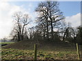
Kingsland Castle (Kingsland)
Here is Kingsland Castle, viewed from one of the bailey earthworks. From this viewpoint, it seems like the motte has shrunk overtime, but you've got to expect that.
Image: © Fabian Musto
Taken: 24 Feb 2018
0.11 miles
10
Kingsland Castle
The motte of Kingsland castle, a Mortimer stronghold from 1247. Henry I gave the land to Philip de Braose in the 1130s and he built a castle of considerable size and importance. No buildings remain but the earthworks are impressive in scale.
Image: © Philip Pankhurst
Taken: 23 Apr 2022
0.11 miles