IMAGES TAKEN NEAR TO
Kingsland, LEOMINSTER, HR6 9QX
Introduction
This page details the photographs taken nearby to HR6 9QX by members of the Geograph project.
The Geograph project started in 2005 with the aim of publishing, organising and preserving representative images for every square kilometre of Great Britain, Ireland and the Isle of Man.

There are currently over 7.5m images from over14,400 individuals and you can help contribute to the project by visiting https://www.geograph.org.uk
Image Map
Images are licensed for reuse under creativecommons.org/licenses/by-sa/2.0
Notes
- Clicking on the map will re-center to the selected point.
- The higher the marker number, the further away the image location is from the centre of the postcode.
Image Listing (16 Images Found)
Images are licensed for reuse under creativecommons.org/licenses/by-sa/2.0
Image
Details
Distance
1
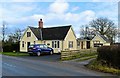
Waterloo Crossing
A handsome bungalow that started life as a Great Western Railway crossing Keeper's cottage. The Leominster to Kington and New Radnor branch crossed here, the last train running in 1964.
Image: © Philip Pankhurst
Taken: 7 Dec 2019
0.01 miles
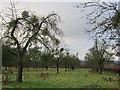
2
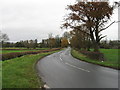
B4360 towards Kingsland
Flat land around the Pinsley Brook.
Image: © Jonathan Billinger
Taken: 13 Feb 2018
0.02 miles
3
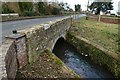
The Pinsley Brook
Diverted and channelled to become the power source for Waterloo mill at Cobnash.
Image: © Philip Pankhurst
Taken: 7 Dec 2019
0.05 miles
5
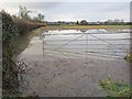
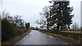
Flooded gateway
View through floods towards Kingsland at a time when much of the Arrow and Lugg floodplains were under water.
Image: © Richard Webb
Taken: 24 Dec 2012
0.05 miles
6
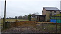
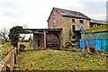
Cobnash Mill
Disused mill building with water wheel still in place by the Pinsley Brook.
Image: © Jonathan Billinger
Taken: 13 Feb 2018
0.06 miles
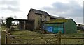
7
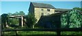
Waterloo Mill (Cobnash)
This stone mill looks like it is derelict at the moment, although the waterwheel is present still. I remember this building a lot when I was a child, since I passed this building every day I went to primary school at Kingsland from 2008 to 2015.
Image: © Fabian Musto
Taken: 29 May 2020
0.06 miles
8
Waterloo Mill, Cobnash
'Waterloo Mill was built as a water-powered corn mill in 1861, replacing an earlier corn mill which stood to the south-west. It was equipped with an undershot waterwheel and an all-iron layshaft gearing system installed by the millwright Richard Miles of Leominster. There is, however, uncertainty as to whether the entire mill complex, which additionally consists of a second mill building (possibly a storehouse) standing to the south-west of the corn mill, a wheel house, a mill house and a range of outbuildings, were constructed at the same time. The entire mill complex is, however, recorded on the first edition Ordnance Survey map of 1887. Furthermore, evidence from the building fabric of the corn mill also suggests that it was either built re-using some of the building material from the earlier mill or that it was either heightened or re-built to some extent between 1861 and 1887. The second edition Ordnance Survey map of 1903 still records the building as being a corn mill but by 1928, when the third edition Ordnance Survey Map was published, it had changed use to a cider mill. In the second half of the C20 the mill closed and the building were used as a livestock farm. In the late-C20 a cart-shed and cattle-shed were added to the site and in the early-C21 the two principal mill buildings were re-slated.' Historic England Listing details - GII listing. A close-up of the water wheel.
Image: © Philip Pankhurst
Taken: 7 Dec 2019
0.06 miles
9
Waterloo Mill, Cobnash
'Waterloo Mill was built as a water-powered corn mill in 1861, replacing an earlier corn mill which stood to the south-west. It was equipped with an undershot waterwheel and an all-iron layshaft gearing system installed by the millwright Richard Miles of Leominster. There is, however, uncertainty as to whether the entire mill complex, which additionally consists of a second mill building (possibly a storehouse) standing to the south-west of the corn mill, a wheel house, a mill house and a range of outbuildings, were constructed at the same time. The entire mill complex is, however, recorded on the first edition Ordnance Survey map of 1887. Furthermore, evidence from the building fabric of the corn mill also suggests that it was either built re-using some of the building material from the earlier mill or that it was either heightened or re-built to some extent between 1861 and 1887. The second edition Ordnance Survey map of 1903 still records the building as being a corn mill but by 1928, when the third edition Ordnance Survey Map was published, it had changed use to a cider mill. In the second half of the C20 the mill closed and the building were used as a livestock farm. In the late-C20 a cart-shed and cattle-shed were added to the site and in the early-C21 the two principal mill buildings were re-slated.' Historic England Listing details - GII listing.
Image: © Philip Pankhurst
Taken: 7 Dec 2019
0.07 miles