IMAGES TAKEN NEAR TO
Quarry Bank Mews, LEOMINSTER, HR6 8GF
Introduction
This page details the photographs taken nearby to Quarry Bank Mews, HR6 8GF by members of the Geograph project.
The Geograph project started in 2005 with the aim of publishing, organising and preserving representative images for every square kilometre of Great Britain, Ireland and the Isle of Man.

There are currently over 7.5m images from over14,400 individuals and you can help contribute to the project by visiting https://www.geograph.org.uk
Image Map
Images are licensed for reuse under creativecommons.org/licenses/by-sa/2.0
Notes
- Clicking on the map will re-center to the selected point.
- The higher the marker number, the further away the image location is from the centre of the postcode.
Image Listing (454 Images Found)
Images are licensed for reuse under creativecommons.org/licenses/by-sa/2.0
Image
Details
Distance
2
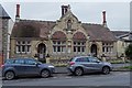
Clarks Hospital
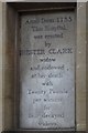
Clarks Hospital are almshouses dating from around 1735, it was foundation, rebuilt 1874. The almshouses are Grade II listed, see: https://historicengland.org.uk/listing/the-list/list-entry/1270334
Image: © Philip Halling
Taken: 10 Dec 2018
0.03 miles
3
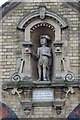
Figure on Clarks Hospital
A figure in the gable of Clarks Hospital, the tablet below is inscribed "He that gives away all before he is Dead, Let em take this Hatchet and knock him on ye head".
Image: © Philip Halling
Taken: 10 Dec 2018
0.03 miles
4
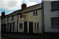
Tiny cottages
These cottages, on the main A44 in Leominster, appeared very small, almost too small to actually live in. Taken from my roofless car as I sat in a queue for the traffic lights.
Image: © John Winder
Taken: 18 Apr 2014
0.03 miles
6
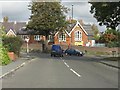
Bargates from Westfield Walk
The building on the other side of Bargates is a primary school.
Image: © Peter Whatley
Taken: 25 Oct 2011
0.07 miles
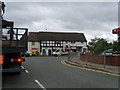
7
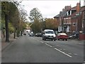
Bargates, looking toward Leominster town centre
The busy A44 passes through a residential area before barely skirting Leominster's central area. HGVs and, in summer, caravan traffic to the Welsh coast can make the road a nightmare for residents. An east-west bypass to complement the A49 north-south bypass is much needed.
Image: © Peter Whatley
Taken: 25 Oct 2011
0.07 miles
8
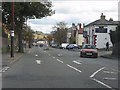
Bargates at Westfield Walk
Westfield Walk is a "rat run" for savvy locals to escape the traffic jams which often arise from the traffic lights at the end of Bargates, just visible in the far distance.
Image: © Peter Whatley
Taken: 25 Oct 2011
0.07 miles
9
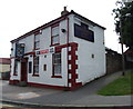
Amore Pizza Kebab House (Leominster)
Placed in Dishley Street is Amore Pizza Kebab House, which opened here in No. 1 after the first COVID-19 lockdown ended.
Image: © Fabian Musto
Taken: 16 Sep 2020
0.08 miles
10
Leaving Leominster
A44 for Brecon to the right
Image: © Michael Graham
Taken: 14 Aug 2009
0.08 miles