IMAGES TAKEN NEAR TO
Etnam Street, LEOMINSTER, HR6 8AJ
Introduction
This page details the photographs taken nearby to Etnam Street, HR6 8AJ by members of the Geograph project.
The Geograph project started in 2005 with the aim of publishing, organising and preserving representative images for every square kilometre of Great Britain, Ireland and the Isle of Man.

There are currently over 7.5m images from over14,400 individuals and you can help contribute to the project by visiting https://www.geograph.org.uk
Image Map
Images are licensed for reuse under creativecommons.org/licenses/by-sa/2.0
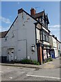
Notes
- Clicking on the map will re-center to the selected point.
- The higher the marker number, the further away the image location is from the centre of the postcode.
Image Listing (775 Images Found)
Images are licensed for reuse under creativecommons.org/licenses/by-sa/2.0
Image
Details
Distance
1
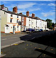
Leominster railway station direction sign
The sign on the left points east along Etnam Street.
Image: © Jaggery
Taken: 16 Oct 2019
0.00 miles
2
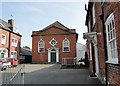
The Baptist Church, Leominster
Dating from 1771.
Image: © Philip Pankhurst
Taken: 10 Apr 2010
0.01 miles
3
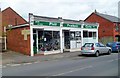
Phill Prothero Cycles, Leominster
Cycle shop on the corner of Etnam Street and Falconer Place.
Image: © Jaggery
Taken: 22 Apr 2012
0.01 miles
4
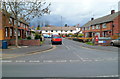
Falconer Place, Leominster
Falconer Place is a cul-de-sac of about 30 houses on the north side of Etnam Street.
Image: © Jaggery
Taken: 22 Apr 2012
0.01 miles
6
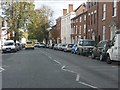
Etnam Street facing west, Leominster, Herefordshire
Image: © Jeff Gogarty
Taken: 17 May 2023
0.02 miles
7
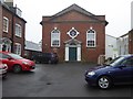
Leominster Baptist Church
Leominster Baptist Church on Etnam Street. The church dates from around 1771 and is a Grade II listed building.
Historic England Description
Chapel. c1771. Brick; hipped plain tile gable roof. Single storey. Central entrance: 6-panel double doors and swagged fanlight under moulded wood open-pediment hood with entablature blocks with triglyphs and guttae, on columns and pilasters (giving appearance of triple columns); bullseye window with coloured glass in brick architrave with 4 stucco keyblocks, dated 1771; flanked by 16-pane round-headed lights under brick semicircular arches with stucco keyblocks; C20 restored brick modillion pediment and parapet. INTERIOR not inspected. Marlow's Court was built in 1771, as a Manse, Chapel and almshouses.
Source: https://www.historicengland.org.uk/listing/the-list/list-entry/1255445
Image: © Philip Halling
Taken: 6 Dec 2016
0.02 miles
8
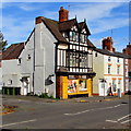
Yellow shop front, 73 Etnam Street, Leominster
There is no name on the shop in October 2019.
Chopsticks Chinese https://www.geograph.org.uk/photo/2912990 was here in April 2012 when the shop was a different colour.
Image: © Jaggery
Taken: 16 Oct 2019
0.02 miles
9
End of row, 73 Etnam Street, Leominster
Image: © Jeff Gogarty
Taken: 17 May 2023
0.02 miles
10
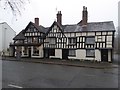
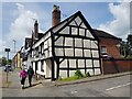
Chequers Inn, Leominster
My first impression was that this building was all part of the Chequers Inn, however, having referred to the Historic England website I discover the inn is just the building to the left and dates from the 16th century See: https://www.historicengland.org.uk/listing/the-list/list-entry/1270300 The buildings to the right are listed as three cottages, 63, 65 and 67, Etnam Street, also dating back to the 16th century. All are Grade II listed buildings. See: https://www.historicengland.org.uk/listing/the-list/list-entry/1255442
Image: © Philip Halling
Taken: 6 Dec 2016
0.02 miles