Leominster Baptist Church
Introduction
The photograph on this page of Leominster Baptist Church by Philip Halling as part of the Geograph project.
The Geograph project started in 2005 with the aim of publishing, organising and preserving representative images for every square kilometre of Great Britain, Ireland and the Isle of Man.

There are currently over 7.5m images from over 14,400 individuals and you can help contribute to the project by visiting https://www.geograph.org.uk
Leominster Baptist Church
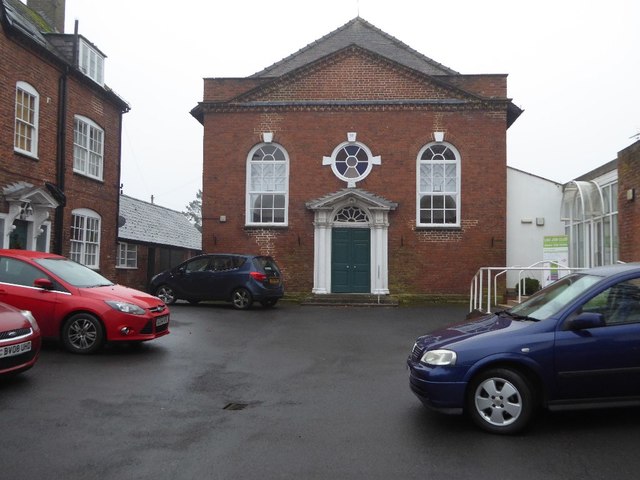
Image: © Philip Halling Taken: 6 Dec 2016
Leominster Baptist Church on Etnam Street. The church dates from around 1771 and is a Grade II listed building. Historic England Description Chapel. c1771. Brick; hipped plain tile gable roof. Single storey. Central entrance: 6-panel double doors and swagged fanlight under moulded wood open-pediment hood with entablature blocks with triglyphs and guttae, on columns and pilasters (giving appearance of triple columns); bullseye window with coloured glass in brick architrave with 4 stucco keyblocks, dated 1771; flanked by 16-pane round-headed lights under brick semicircular arches with stucco keyblocks; C20 restored brick modillion pediment and parapet. INTERIOR not inspected. Marlow's Court was built in 1771, as a Manse, Chapel and almshouses. Source: https://www.historicengland.org.uk/listing/the-list/list-entry/1255445
Images are licensed for reuse under creativecommons.org/licenses/by-sa/2.0
Image Location
Latitude
52.225923
Longitude
-2.734737