IMAGES TAKEN NEAR TO
Marlbrook, LEOMINSTER, HR6 0PE
Introduction
This page details the photographs taken nearby to HR6 0PE by members of the Geograph project.
The Geograph project started in 2005 with the aim of publishing, organising and preserving representative images for every square kilometre of Great Britain, Ireland and the Isle of Man.

There are currently over 7.5m images from over14,400 individuals and you can help contribute to the project by visiting https://www.geograph.org.uk
Image Map
Images are licensed for reuse under creativecommons.org/licenses/by-sa/2.0
Notes
- Clicking on the map will re-center to the selected point.
- The higher the marker number, the further away the image location is from the centre of the postcode.
Image Listing (5 Images Found)
Images are licensed for reuse under creativecommons.org/licenses/by-sa/2.0
Image
Details
Distance
1
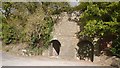
Limekiln, Marlbrook
Most of the rock here is old red sandstone which often produces acid soil. Every now and then, limestone outcrops and it was roasted for lime which would raise soil pH and crop yields. Here there is a band of Devonian Bishop's Frome limestone which outcrops around Brierley Woods.
Image: © Richard Webb
Taken: 10 Oct 2017
0.03 miles
3
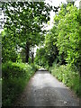
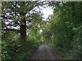
Track To Pervin Farm
This lower portion of the track also provides access to several houses and is to a considerably better standard than the upper section.
Image: © Peter Whatley
Taken: 22 Jun 2009
0.18 miles