IMAGES TAKEN NEAR TO
Bircher, LEOMINSTER, HR6 0BP
Introduction
This page details the photographs taken nearby to HR6 0BP by members of the Geograph project.
The Geograph project started in 2005 with the aim of publishing, organising and preserving representative images for every square kilometre of Great Britain, Ireland and the Isle of Man.

There are currently over 7.5m images from over14,400 individuals and you can help contribute to the project by visiting https://www.geograph.org.uk
Image Map
Images are licensed for reuse under creativecommons.org/licenses/by-sa/2.0
Notes
- Clicking on the map will re-center to the selected point.
- The higher the marker number, the further away the image location is from the centre of the postcode.
Image Listing (13 Images Found)
Images are licensed for reuse under creativecommons.org/licenses/by-sa/2.0
Image
Details
Distance
1
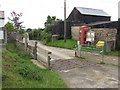
Telephone box, Bircher Common
Grid and phone box at the head of Welshman's Lane.
Image: © Richard Webb
Taken: 10 Aug 2010
0.10 miles
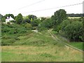
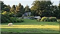
2
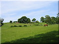
Fields on the path from Bircher Common to Yarpole
A lush Herefordshire meadow (and horse) at about SO 464657.
Image: © Raymond Perry
Taken: 7 Jun 2005
0.16 miles
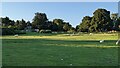
3
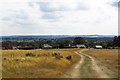
Lower Bircher Common
Taken at the height of the scorching heatwave of summer 2018. In the distance, Morgan Hill and Brierley Wood are to the left, and Birley Hill is on the right. Oaker Wood is in the middle distance to the right. Leominster is barely visible in the dip to the left.
Image: © Z Pryce
Taken: 27 Jul 2018
0.16 miles
4
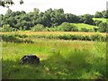
Small fields, Bircher
A small grass field off Welshman's Lane. The "beast" is an old rotting round silage bale.
Image: © Richard Webb
Taken: 9 Aug 2010
0.18 miles
5
Bircher Common
Some of the cottages and former cottages (lots of extensions) that line the lower slopes of Bircher Common, along the spring line. Higher up on the limestone ridge (akin to downland on chalk, here on Silurian mudstones) is often too dry for settlement.
Image: © Richard Webb
Taken: 10 Aug 2010
0.19 miles
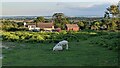
6
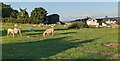
Sheep at Bircher Common
There were hundreds of sheep grazing in the southern section at Bircher Common when I visited in the evening.
Image: © Fabian Musto
Taken: 13 Jul 2021
0.21 miles
7
Bircher Common
Here is Bircher Common in the civil parish of Croft and Yarpole, owned by the National Trust. The common is an area of lowland heath that is situated to Croft Castle, which is also a National Trust property.
Image: © Fabian Musto
Taken: 13 Jul 2021
0.21 miles
8
Sheep at Bircher Common
There were hundreds of sheep grazing in the southern section at Bircher Common when I visited in the evening.
Image: © Fabian Musto
Taken: 13 Jul 2021
0.21 miles
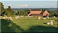
9
Houses on Bircher Common
These houses are placed at the lower section of Bircher Common.
Image: © Fabian Musto
Taken: 13 Jul 2021
0.21 miles
10
Primitive Methodist Chapel (Bircher)
The primitive Methodist chapel at Bircher Common was built in 1841, and this was later known as Bircher Methodist Church. The church closed in the 1980s, and was converted to a private house in 1996.
Image: © Fabian Musto
Taken: 13 Jul 2021
0.21 miles