IMAGES TAKEN NEAR TO
The Paddocks, AYLESBURY, HP22 6HE
Introduction
This page details the photographs taken nearby to The Paddocks, HP22 6HE by members of the Geograph project.
The Geograph project started in 2005 with the aim of publishing, organising and preserving representative images for every square kilometre of Great Britain, Ireland and the Isle of Man.

There are currently over 7.5m images from over14,400 individuals and you can help contribute to the project by visiting https://www.geograph.org.uk
Image Map (Loading...)


Getting Data...Please wait
Leaflet Map data © OpenStreetMap
Images are licensed for reuse under creativecommons.org/licenses/by-sa/2.0
Notes
- Clicking on the map will re-center to the selected point.
- The higher the marker number, the further away the image location is from the centre of the postcode.
Image Listing (53 Images Found)
Images are licensed for reuse under creativecommons.org/licenses/by-sa/2.0
Image
Details
Distance
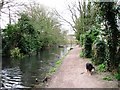
1
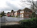
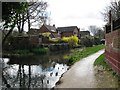
Wendover Arm: The Paddocks, Wendover
Initially modern housing developments come close to the edge of the canal – further north the canal runs through fields or woodland.
See Image
Image: © Chris Reynolds
Taken: 25 Mar 2009
0.01 miles
2
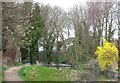
Wendover Arm: Looking towards the Winding Hole
The Winding Hole was the end of navigation when the Wendover arm was in use, and allowed the barges to turn round.
See Image
Image: © Chris Reynolds
Taken: 25 Mar 2009
0.03 miles
3
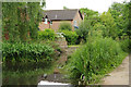
The Wendover Arm, Wendover
Houses beside the end of the disused canal.
Image: © Stephen McKay
Taken: 4 Jul 2017
0.03 miles
4
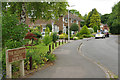
The Paddocks, Wendover
The Paddocks leads off Wharf Road and provides an access route to the old canal towpath.
Image: © Stephen McKay
Taken: 4 Jul 2017
0.03 miles
5
Wendover Arm: Along the Canal-side Footpath
The built up edge of the canal in the distance is associated with the Paddocks housing development.
See Image
Image: © Chris Reynolds
Taken: 25 Mar 2009
0.04 miles
6
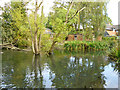
Wendover Wharf
At the end of the currently unnavigable canal. The small building beyond the rushes appears to be one of the original wharf buildings. It is in great need of repair before it falls down.
Image: © Robin Webster
Taken: 21 Sep 2014
0.04 miles
7
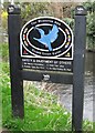
The Wendover Arm of the Grand Union Canal
This sign was erected to record the Arm's 200th Anniversary.
Photographs of interesting features all along the canal will appear in the following geographs.
Image The Towpath is part of the Aylesbury Ring Walk. This section starts with the former Wendover Wharf and a winding hole, and also includes a wooden footbridge on the site of an earlier railway bridge http://en.wikipedia.org/wiki/Halton_Railway
Image This section provides a pleasant stream-side walk with extensive marsh on The Wides (spreading into Image and crossed by the Perch Bridge).
Image A pleasant rural chalk stream with no particular canal features.
Image Passes through the village of Halton, with a modern road bridge and a highly ornate bridge built by the Rothschilds of Halton House. It also includes Harelane Bridge.
Image A pleasant rural chalk stream with no particular canal features.
Image This disused section of the canal includes “The Narrows” and Wellonhead Bridge
Image This section of the canal is watered, with fields on one side and 20 century house (Aston Clinton) on the other. At Buckland Wharf there are two road bridges which will be an obstacle to navigation when Phase II to reopening the canal is completed.
Image This includes the section of the canal which was relocated and refurbished with the building of the Aston Clinton Bypass. It includes an original road bridge at Drayton Beauchamp.
Image This section is in the process of being restored. The first short section was filled in November 2007 and work is continuing back towards Little Tring.
Image Currently (2009) the “dry” section of the canal is a ditch of glutinous mud which has been bridged by a footbridge (No 4) in order to keep an existing right of way open. It also includes the end of the watered section of the canal, including the recently opened winding hole, the rebuilt little Tring Bridge, the site of the old stop lock and the Little Tring Pumping Station.
Image A short section of the canal which is currently being restored. At the eastern end the old canal trench was used as the town refuse dump in the early 20th century.
Image This section includes the Tring Feeder and the site of Bushell's Wharf. The annual Wendover Arm Festival is held in a field adjoining the canal.
Image Features here include Tring Wharf at New Mill, the humpbacked bridge at New Mill, and the inflow from Tring sewerage works. At the north-east end it joins the Grand Union Canal at the Tring Summit.
Image: © Chris Reynolds
Taken: 25 Mar 2009
0.05 miles
8
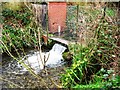
Wendover Arm: The Water Flow Gauge
Water flow into the Canal has been measured since 1844 – and the records provide one of the longest continuous records of water flow in the world.
See Image
Image: © Chris Reynolds
Taken: 25 Mar 2009
0.05 miles
9
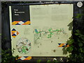
Information Board re The Wendover Arm (1)
This information board is located at the south end of the Wendover Arm canal in Wharf Road HP22 6HF. It has the following wording:
Top left
Wendover's Waterway. The Wendover Arm is a living history rewarding the
travellers of today with glimpses of the past. Its trading days now over,
the canal winds its quiet way between open fields and shady woods, past
abandoned wharfs and railway crossings, a Rothschild mansion and a
redundant quarry. Equally of interest is the abundant wildlife which now
takes refuge on, in, and around the waterway amongst its reedbeds, and
along its hedgerows.
Clinging to its contour at the base of the Chiltern Hills, the Arm is a
product of the very landform which also brought about its eventual
downfall, as this and other panels will explain.
Top Right
"The Leaky Canal" At the end of the eighteenth century the Grand Junction
Canal (now known as the Grand Union Canal), was in need of extra water to
carry its increasing traffic. The Wendover Arm started as an idea for
supplying the Grand Union with water taken from spring lines near Wendover.
Work began in 1793 and plans were quickly adapted to build the arm as a
navigable link to the village.
Within 5 years of its opening in 1797 it was obvious that the canal was
leaking. Despite several attempts to cure the leaks, water loss increased
over the next 100 years to the extent that the Arm began to drain the Grand
Union Canal! Finally, a stop-lock was constructed at Tringford and the
remainder of the Arm was abandoned in 1904, its water being diverted
underground to Wilstone Reservoir.
Middle
Map of the Wendover Arm canal with the following locations indicated from
left to right.
i) Weston Turville Reservoir constructed in 1799 to divert excess water
into the Wendover stream. It is now an important area for wildlife.
ii) Perch Bridge (iron bridge)
iii) Wendover Wharf. Wendover Arm wharf sent local produce to London and
received coal, timber and manure.
iv) Winding Hole for turning barges once unloaded.
v) Railway Crossing crossing of the branch line from Wendover to Halton
Camp.
vi) The Wides a low lying wetland area with a variety of interesting
wildlife.
vii) Halton Village the Rothschild family built a number of houses in
Halton. Many bear coats of arms and pictures depicting country scenes.
viii) Halton Camp the RAF bought the Rothschild estate and moved there in
1918, It became an important station.
ix) Halton Camp Airfield
x) Rothschild Bridge cast iron bridge built in 1880 by the Rothschilds and
bears the coat of arms.
xi) Halton House built in 1884 by Alfred de Rothschild in a French
Chateau style, and now owned by the RAF.
xii) Green Park originally owned by Anthony de Rothschild who rebuilt
Aston Clinton Manor in 1860.
xiii) Cobblers Pits old disused pits and sunken lane now overgrown by
mixed woodland.
xiv) Buckland Wharf the hamlet is named after the wharf which used to lie
in front of the neighbouring cottages.
Lower left
Circular map of the Wendover Arm canal and its surroundings
Lower middle
The Wendover Arm Trust are seeking to make the Arm navigable again. If you
wish to find out more information about their work, contact Roger Lewis
(Tel No: 01442 823378).
Lower right
Walking the Wendover Arm. Approximately 6 miles of the Arm's original 6
miles 1348 yards can be walked. The 3 miles from Wendover to the car park
at Stablebridge Road, Aston Clinton were repaired in 1993 to a surface
suitable for wheelchairs or pushchairs. A leaflet is available from
Buckinghamshire County Council highlighting circular walks which use
sections of the Arm.
Image: © David Hillas
Taken: 31 May 2021
0.05 miles
10
Wendover Arm: Head of the Wendover Arm
See Image
Image: © Chris Reynolds
Taken: 25 Mar 2009
0.05 miles