Information Board re The Wendover Arm (1)
Introduction
The photograph on this page of Information Board re The Wendover Arm (1) by David Hillas as part of the Geograph project.
The Geograph project started in 2005 with the aim of publishing, organising and preserving representative images for every square kilometre of Great Britain, Ireland and the Isle of Man.

There are currently over 7.5m images from over 14,400 individuals and you can help contribute to the project by visiting https://www.geograph.org.uk
Information Board re The Wendover Arm (1)
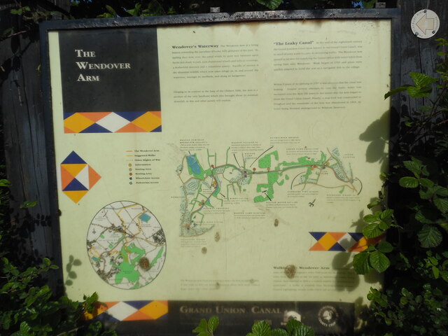
Image: © David Hillas Taken: 31 May 2021
This information board is located at the south end of the Wendover Arm canal in Wharf Road HP22 6HF. It has the following wording: Top left Wendover's Waterway. The Wendover Arm is a living history rewarding the travellers of today with glimpses of the past. Its trading days now over, the canal winds its quiet way between open fields and shady woods, past abandoned wharfs and railway crossings, a Rothschild mansion and a redundant quarry. Equally of interest is the abundant wildlife which now takes refuge on, in, and around the waterway amongst its reedbeds, and along its hedgerows. Clinging to its contour at the base of the Chiltern Hills, the Arm is a product of the very landform which also brought about its eventual downfall, as this and other panels will explain. Top Right "The Leaky Canal" At the end of the eighteenth century the Grand Junction Canal (now known as the Grand Union Canal), was in need of extra water to carry its increasing traffic. The Wendover Arm started as an idea for supplying the Grand Union with water taken from spring lines near Wendover. Work began in 1793 and plans were quickly adapted to build the arm as a navigable link to the village. Within 5 years of its opening in 1797 it was obvious that the canal was leaking. Despite several attempts to cure the leaks, water loss increased over the next 100 years to the extent that the Arm began to drain the Grand Union Canal! Finally, a stop-lock was constructed at Tringford and the remainder of the Arm was abandoned in 1904, its water being diverted underground to Wilstone Reservoir. Middle Map of the Wendover Arm canal with the following locations indicated from left to right. i) Weston Turville Reservoir constructed in 1799 to divert excess water into the Wendover stream. It is now an important area for wildlife. ii) Perch Bridge (iron bridge) iii) Wendover Wharf. Wendover Arm wharf sent local produce to London and received coal, timber and manure. iv) Winding Hole for turning barges once unloaded. v) Railway Crossing crossing of the branch line from Wendover to Halton Camp. vi) The Wides a low lying wetland area with a variety of interesting wildlife. vii) Halton Village the Rothschild family built a number of houses in Halton. Many bear coats of arms and pictures depicting country scenes. viii) Halton Camp the RAF bought the Rothschild estate and moved there in 1918, It became an important station. ix) Halton Camp Airfield x) Rothschild Bridge cast iron bridge built in 1880 by the Rothschilds and bears the coat of arms. xi) Halton House built in 1884 by Alfred de Rothschild in a French Chateau style, and now owned by the RAF. xii) Green Park originally owned by Anthony de Rothschild who rebuilt Aston Clinton Manor in 1860. xiii) Cobblers Pits old disused pits and sunken lane now overgrown by mixed woodland. xiv) Buckland Wharf the hamlet is named after the wharf which used to lie in front of the neighbouring cottages. Lower left Circular map of the Wendover Arm canal and its surroundings Lower middle The Wendover Arm Trust are seeking to make the Arm navigable again. If you wish to find out more information about their work, contact Roger Lewis (Tel No: 01442 823378). Lower right Walking the Wendover Arm. Approximately 6 miles of the Arm's original 6 miles 1348 yards can be walked. The 3 miles from Wendover to the car park at Stablebridge Road, Aston Clinton were repaired in 1993 to a surface suitable for wheelchairs or pushchairs. A leaflet is available from Buckinghamshire County Council highlighting circular walks which use sections of the Arm.
Images are licensed for reuse under creativecommons.org/licenses/by-sa/2.0
Image Location
Latitude
51.765828
Longitude
-0.74142