IMAGES TAKEN NEAR TO
Brewhouse Lane, AYLESBURY, HP22 4QT
Introduction
This page details the photographs taken nearby to Brewhouse Lane, HP22 4QT by members of the Geograph project.
The Geograph project started in 2005 with the aim of publishing, organising and preserving representative images for every square kilometre of Great Britain, Ireland and the Isle of Man.

There are currently over 7.5m images from over14,400 individuals and you can help contribute to the project by visiting https://www.geograph.org.uk
Image Map
Images are licensed for reuse under creativecommons.org/licenses/by-sa/2.0
Notes
- Clicking on the map will re-center to the selected point.
- The higher the marker number, the further away the image location is from the centre of the postcode.
Image Listing (16 Images Found)
Images are licensed for reuse under creativecommons.org/licenses/by-sa/2.0
Image
Details
Distance
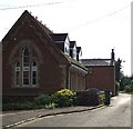
1
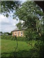
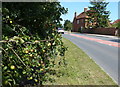
Former Independent Chapel, Rowsham
At the end of Brewhouse Lane in Rowsham and slightly to the north is this little building, viewed here across a field from Brewhouse Lane. I think that it is now a private house, however looking at an 1880s map it is marked as an Independent chapel.
Image: © Rob Farrow
Taken: 6 Jul 2006
0.01 miles
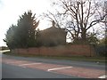
2
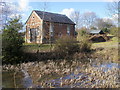
Independent Chapel
Independent Chapel on Brewhouse Lane Rowsham
Image: © Shaun Ferguson
Taken: 1 Mar 2010
0.01 miles
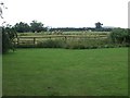
3
Track off the A418, Rowsham
It leads to a path to Nup End across the fields.
Image: © David Howard
Taken: 11 Feb 2018
0.05 miles
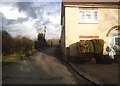
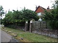
4
Former Infant School, Rowsham
A view along Brewhouse Lane in Rowsham. The nearest building used to be a little infants school, though now it is a private house. The more distant building might have been a chapel, as a chapel is marked on the OS maps in approximately its position. However, this Image certainly was a chapel, so perhaps it was marked on the map incorrectly.
Image: © Rob Farrow
Taken: 6 Jul 2006
0.07 miles
7
Fields & Hay Bales
The view across a paddock-like field to fields beyond with hay baled ready for collection. A footpath strikes off to the North-northwest here from the very busy A418 through Rowsham. I think that the trees in the mid-distance on the left are surrounding a little pond.
Image: © Rob Farrow
Taken: 6 Jul 2006
0.13 miles
8
Old Hale Farmhouse
This old farmhouse is at the end of Bennetts Lane, a dead-end lane in Rowsham
Image: © Rob Farrow
Taken: 6 Jul 2006
0.13 miles
9
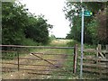
Yes, there are two paths you can go by ...
A choice of paths at the end of Bennetts Lane in Rowsham. The one ahead strikes of eastwards towards a property called Ridgway, while the one to the right going southwards is Image and joins up with the Aylesbury Ring LDP. (LDP = Long Distance Path)
Image: © Rob Farrow
Taken: 6 Jul 2006
0.14 miles
10
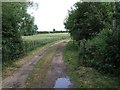
The track to Seabrook Farm
This lane to Seabrook Farm is also a public footpath. It heads off southwards from the end of Bennetts Lane in Rowsham. See also Image
Image: © Rob Farrow
Taken: 6 Jul 2006
0.14 miles