IMAGES TAKEN NEAR TO
Naphill Common, HIGH WYCOMBE, HP14 4SU
Introduction
This page details the photographs taken nearby to Naphill Common, HP14 4SU by members of the Geograph project.
The Geograph project started in 2005 with the aim of publishing, organising and preserving representative images for every square kilometre of Great Britain, Ireland and the Isle of Man.

There are currently over 7.5m images from over14,400 individuals and you can help contribute to the project by visiting https://www.geograph.org.uk
Image Map
Images are licensed for reuse under creativecommons.org/licenses/by-sa/2.0
Notes
- Clicking on the map will re-center to the selected point.
- The higher the marker number, the further away the image location is from the centre of the postcode.
Image Listing (9 Images Found)
Images are licensed for reuse under creativecommons.org/licenses/by-sa/2.0
Image
Details
Distance
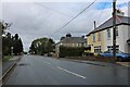
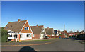
2
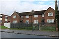
Ash Close, Walter's Ash
The southern end of the cul-de-sac which consists of bungalows and semi-detached houses.
Image: © Andrew Smith
Taken: 4 Jul 2010
0.14 miles
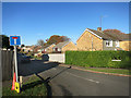
4
Battingswood Gardens, Walter's Ash
Battings Wood is at the other end of the street.
Image: © Des Blenkinsopp
Taken: 28 Nov 2016
0.18 miles
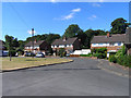
6
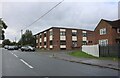
Main Road, Walter's Ash
The block is part of RAF High Wycombe which is spread along the road.
Image: © David Howard
Taken: 27 Sep 2022
0.20 miles
7
Bradenham National Trust woodland
Bradenham National Trust woodland off Bradenham Woods lane
Image: © Shaun Ferguson
Taken: 20 Sep 2008
0.23 miles
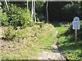
8
Footpath Crossing, Naphill Common
Naphill Common is woodland and is crossed by numerous public footpaths.
This is just one of many intersections.
Image: © Des Blenkinsopp
Taken: 28 Nov 2016
0.24 miles
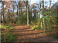
9
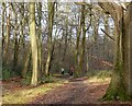
Woodland, Hughenden
One of many footpaths on Naphill Common approaches the junction with a bridleway that has climbed from Bradenham.
Image: © Andrew Smith
Taken: 2 Jan 2022
0.25 miles