IMAGES TAKEN NEAR TO
Valley Road, HIGH WYCOMBE, HP14 4LD
Introduction
This page details the photographs taken nearby to Valley Road, HP14 4LD by members of the Geograph project.
The Geograph project started in 2005 with the aim of publishing, organising and preserving representative images for every square kilometre of Great Britain, Ireland and the Isle of Man.

There are currently over 7.5m images from over14,400 individuals and you can help contribute to the project by visiting https://www.geograph.org.uk
Image Map (Loading...)


Getting Data...Please wait
Leaflet Map data © OpenStreetMap
Images are licensed for reuse under creativecommons.org/licenses/by-sa/2.0
Notes
- Clicking on the map will re-center to the selected point.
- The higher the marker number, the further away the image location is from the centre of the postcode.
Image Listing (37 Images Found)
Images are licensed for reuse under creativecommons.org/licenses/by-sa/2.0
Image
Details
Distance
1
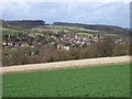
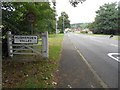
Hughenden Valley
Hughenden Valley is a modern residential village. A view across fields from the Hughenden to Cryer's Hill footpath.
Image: © Andrew Smith
Taken: 2 Apr 2006
0.04 miles
2
Hughenden Stream: The source in Hughenden Valley
Hughenden Stream rises from various springs in the Hughenden Valley. This location next to Valley Road is about the first location where there is a recognisable ditch, although the stream bed is usually dry here.
Image: © Nigel Cox
Taken: 11 Aug 2016
0.04 miles
3
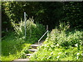
Steps to Public Footpath at Hughenden Valley
Steps at Valley Road onto path to St Michael & All Angels Church at Hughenden Manor.
Image: © Sean Davis
Taken: 28 Jul 2007
0.05 miles
4
Out to Valley Road at Hughenden Valley
Public footpath from Hughenden Manor leads down steps and out to Valley Road at Hughenden Valley, on the route of the London Green Belt Way.
Image: © Sean Davis
Taken: 28 Jul 2007
0.05 miles
5
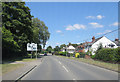
Hughenden Valley: Valley Road
The village of Hughenden Valley is very much a 20th Century development. A review of the large scale Ordnance Survey map of about 1875 shows nothing but farmland and a few isolated farms, such as Bottom and Bosslane Farms.
Image: © Nigel Cox
Taken: 11 Aug 2016
0.06 miles
6
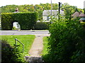
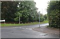
Valley Road junction with Combe Lane & Boss Lane
Image: © Stuart Logan
Taken: 30 Jul 2014
0.07 miles
7
Coombe Lane, Hughenden Valley
From Valley Road
Image: © David Howard
Taken: 27 Sep 2022
0.07 miles
8
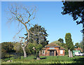
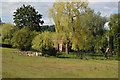
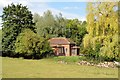
Hughenden Valley Pumping Station
Located at the source of the Hughenden Stream, a chalk stream which now only flows on the rare occasions when the water table is high enough.
The balance between river flow and groundwater abstraction is a problem over much of southern England.
One effect of this may be the dead tree. Only two years ago it was a beautiful willow, as seen here Image but we have had some dry summers since then.
Image: © Des Blenkinsopp
Taken: 18 Sep 2019
0.08 miles