IMAGES TAKEN NEAR TO
Marfield Quarry, RIPON, HG4 4NX
Introduction
This page details the photographs taken nearby to Marfield Quarry, HG4 4NX by members of the Geograph project.
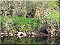
The Geograph project started in 2005 with the aim of publishing, organising and preserving representative images for every square kilometre of Great Britain, Ireland and the Isle of Man.

There are currently over 7.5m images from over14,400 individuals and you can help contribute to the project by visiting https://www.geograph.org.uk
Image Map
Images are licensed for reuse under creativecommons.org/licenses/by-sa/2.0
Notes
- Clicking on the map will re-center to the selected point.
- The higher the marker number, the further away the image location is from the centre of the postcode.
Image Listing (14 Images Found)
Images are licensed for reuse under creativecommons.org/licenses/by-sa/2.0
Image
Details
Distance
1
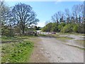
Car park for Marfield Wetlands Nature Reserve
Adjoining Nunnery Nook.
Image: © Oliver Dixon
Taken: 5 May 2013
0.04 miles
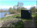
2
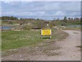
Marfield Wetlands
Old gravel pits which are now a local nature reserve. Looking north-west along the central strip of land between lakes on either side. There is a voluntary closure of this central path during the nesting season (see the noticeboard); and steps are being taken to officially close this path in favour of a perimeter path which will cause less disturbance to wildlife.
Image: © Oliver Dixon
Taken: 5 May 2013
0.06 miles
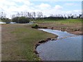
3
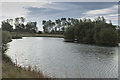
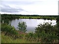
Marfield Nature Reserve
One of the smaller lakes at Marfield.
Image: © Malcolm Neal
Taken: 2 Oct 2018
0.11 miles
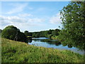
4
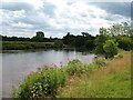
A bend in the Ure
Approaching Masham by the riverside path, close enough to see the church spire, but not close enough to smell the malt at the town's two breweries.
Image: © Gordon Hatton
Taken: 14 Jul 2009
0.14 miles
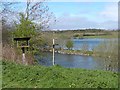
5
Lake Hide, Marfield Wetlands Nature Reserve
Old gravel pits which are now a local nature reserve.
Image: © Oliver Dixon
Taken: 5 May 2013
0.16 miles
6
Marfield Wetlands
Old gravel pits which are now a local nature reserve. Looking south-east along the central strip of land between lakes on either side. There is a voluntary closure of this central path during the nesting season; and steps are being taken to officially close this path in favour of a perimeter path which will cause less disturbance to wildlife.
Image: © Oliver Dixon
Taken: 5 May 2013
0.18 miles
7
Marfield Wetlands Nature Reserve
Old gravel pits which are now a local nature reserve. Seen from the Lake Hide.
Image: © Oliver Dixon
Taken: 5 May 2013
0.18 miles
8
The River Ure looking upstream from above Masham
Image: © C P Smith
Taken: 3 Jul 2011
0.21 miles
9
VERY old railway bridge
This is a redundant railway bridge from the remains of the old narrow gauge railway that was built for the construction of the Leighton and Roundhill dams at the top end of the valley of the River Burn? This line started in the field opposite Masham station [SE233813], crossed the Ure somewhere north of the road bridge, then made its way up past Healey etc. A few traces of it can be found in the Burn valley and nearer the reservoirs. The standard gauge line ended at the station which is now the caravan site.
Many thanks to Gordon Hatton for correcting my original posting
Image: © Nick W
Taken: 15 Apr 2007
0.22 miles
10
Marfield Nature Reserve
Old gravel workings in glacial deposits near Masham, now a nature reserve.
Image: © Gordon Hatton
Taken: 26 Jul 2010
0.23 miles