IMAGES TAKEN NEAR TO
North Stainley, RIPON, HG4 3JB
Introduction
This page details the photographs taken nearby to HG4 3JB by members of the Geograph project.
The Geograph project started in 2005 with the aim of publishing, organising and preserving representative images for every square kilometre of Great Britain, Ireland and the Isle of Man.

There are currently over 7.5m images from over14,400 individuals and you can help contribute to the project by visiting https://www.geograph.org.uk
Image Map
Images are licensed for reuse under creativecommons.org/licenses/by-sa/2.0
Notes
- Clicking on the map will re-center to the selected point.
- The higher the marker number, the further away the image location is from the centre of the postcode.
Image Listing (18 Images Found)
Images are licensed for reuse under creativecommons.org/licenses/by-sa/2.0
Image
Details
Distance
1
Old Sleningford Farm
Old Sleningford Farm advertises charcoal for sale.
Image: © David Rogers
Taken: 6 Jul 2008
0.03 miles
2
Old Sleningford Water Mill
Now I'd assumed that this had been built as a corn mill, but on the 1st Ed. OS Map it is marked as a Thrashing Mill.
Machinery survives inside with gearing and stones, and the remains of an iron clad water wheel. It has been disused since WW2. It is Grade 2 Listed.
The old mill pond has been incorporated into the landscaped garden of Old Sleningford Hall.
Image: © Matthew Hatton
Taken: 2 Jun 2019
0.05 miles
3
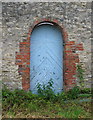
Old Sleningford Farm
An interesting design on this blue door at Old Sleningford Farm.
Image: © David Rogers
Taken: 6 Jul 2008
0.06 miles
4
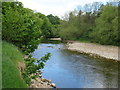
A bend in the river
Looking upstream along the Ure which disappears from view at this point and is not seen again from the Tanfield to Mickley path.
Image: © Gordon Hatton
Taken: 13 May 2020
0.15 miles
5
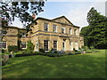
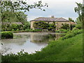
Old Sleningford Hall
Early 19thC country house with extensive walled kitchen garden. Grade 2 Listed.
Image: © Matthew Hatton
Taken: 2 Jun 2019
0.15 miles
6

River Ure between West Tanfield and Mickley
The river runs between a mixture of pasture and woodland at this point - looking upstream here.
Image: © Chris Heaton
Taken: 2 May 2012
0.15 miles
7
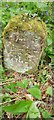
Old Boundary Stone at Old Sleningford
Strange prose 'Here Old Sleningford Ends' although it is still the boundary with Grewelthorpe & Mickley
Image: © Matthew Hatton
Taken: 29 Apr 2020
0.18 miles
8
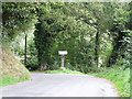
Minor road junction at Old Sleningford
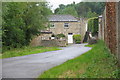
A junction of minor roads east of Mickley. To the right is the road to Kirkby Malzeard and the left fork is towards North Stainley.
Image: © Gordon Hatton
Taken: 20 Aug 2018
0.21 miles
10
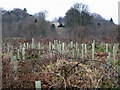
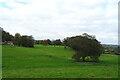
New Planting
Old Sleningford can be seen through the trees.
Image: © David Rogers
Taken: 28 Dec 2008
0.21 miles