IMAGES TAKEN NEAR TO
Summerbridge, HARROGATE, HG3 4JS
Introduction
This page details the photographs taken nearby to HG3 4JS by members of the Geograph project.
The Geograph project started in 2005 with the aim of publishing, organising and preserving representative images for every square kilometre of Great Britain, Ireland and the Isle of Man.

There are currently over 7.5m images from over14,400 individuals and you can help contribute to the project by visiting https://www.geograph.org.uk
Image Map (Loading...)


Getting Data...Please wait
Leaflet Map data © OpenStreetMap
Images are licensed for reuse under creativecommons.org/licenses/by-sa/2.0
Notes
- Clicking on the map will re-center to the selected point.
- The higher the marker number, the further away the image location is from the centre of the postcode.
Image Listing (29 Images Found)
Images are licensed for reuse under creativecommons.org/licenses/by-sa/2.0
Image
Details
Distance
1
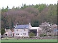
White Oak farmhouse
A nineteenth century rebuild of a 17th century house in Nidderdale. An odd combination of old looking stone mullioned windows with a slate roof and 20th century doorway. The house is grade 2 listed.
Image: © Gordon Hatton
Taken: 15 Apr 2012
0.04 miles
2
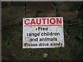
Free Range children
Probably the friendliest and most effective speed reduction sign I've seen!! Outside White Oaks Farm, Nidderdale
Image: © Allan Friswell
Taken: 3 Jan 2009
0.06 miles
3
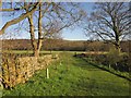
Bridleway near Birchfield Farm
Bridleway 15 91/6/2 runs along this pleasant grassy track to the gate, and then crosses the field over the Nidd flood plain shown in Image, with an unnamed wood on the far bank
Image: © Derek Harper
Taken: 5 Apr 2012
0.08 miles
4
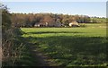
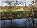
Farmland by the Nidd
Taken just north of Image, with bridleway 15 91/6/2 crossing the flood plain of the river towards Birchfield Farm. The farmhouse http://list.english-heritage.org.uk/resultsingle.aspx?uid=1207451&searchtype=mapsearch and four adjacent structures are listed. Behind the farm is Tanpit Wood.
Image: © Derek Harper
Taken: 5 Apr 2012
0.13 miles
5
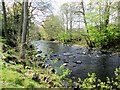
River Nidd
Looking across the river from the Nidderdale Way following 15 91/55/2. Against the background of Willie's Wood is White Oak Farm - see Image The farmhouse http://list.english-heritage.org.uk/resultsingle.aspx?uid=1207437&searchtype=mapsearch and two of its outbuildings are listed.
Image: © Derek Harper
Taken: 5 Apr 2012
0.15 miles
6
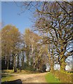
Footpath past Tanpit Wood
Footpath number 15 55/100/1 leaves Birchfield Farm along this track, keeping to the right of the wood.
Image: © Derek Harper
Taken: 5 Apr 2012
0.15 miles
7

Nidderdale Way
Approaching the footbridge across the River Nidd shown in Image
Image: © Derek Harper
Taken: 5 Apr 2012
0.17 miles
8
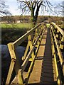
Footbridge over the Nidd
Image: © Derek Harper
Taken: 5 Apr 2012
0.17 miles
10

Old Boundary Marker
Knaresborough Forest Enclosure Boundary Marker on the north bank of the River Nidd 200 metres south of White Oak, at the side of a footpath leading to a footbridge. On the boundary of Hartwith cum Winsley and Darley and Menwith parishes. Only 32 visible with K · F / 1767 presumably buried. Erected to delineate the Forest of Knaresborough preparatory to enclosure.
Milestone Society National ID: YW_KF32pb
Image: © D Garside
Taken: 7 May 2013
0.17 miles