IMAGES TAKEN NEAR TO
Pateley Bridge Road, HARROGATE, HG3 3ET
Introduction
This page details the photographs taken nearby to Pateley Bridge Road, HG3 3ET by members of the Geograph project.
The Geograph project started in 2005 with the aim of publishing, organising and preserving representative images for every square kilometre of Great Britain, Ireland and the Isle of Man.

There are currently over 7.5m images from over14,400 individuals and you can help contribute to the project by visiting https://www.geograph.org.uk
Image Map
Images are licensed for reuse under creativecommons.org/licenses/by-sa/2.0
Notes
- Clicking on the map will re-center to the selected point.
- The higher the marker number, the further away the image location is from the centre of the postcode.
Image Listing (11 Images Found)
Images are licensed for reuse under creativecommons.org/licenses/by-sa/2.0
Image
Details
Distance
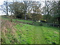
2
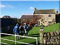
Dinmore House
Near Burnt Yates, and beside Catstone Woods in the valley of the River Nidd
Image: © Chris Heaton
Taken: 8 Nov 2006
0.07 miles
3
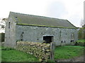
Barn by Catstone Wood
Situated at the extreme northern point of Catstone Wood, just outside the grounds of Dinmore House. The barn or laithe is in poor condition
Image: © Chris Heaton
Taken: 8 Nov 2006
0.08 miles
4
Footpath beside Catstone Wood
Following a footpath from Dinmore House, edging past the northern tip of Catstone Woods before crossing fields to Burnt Yates
Image: © Chris Heaton
Taken: 8 Nov 2006
0.14 miles
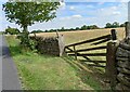
5
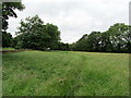
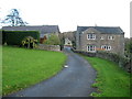
Pasture by Dinmore House
Pasture to the west of Dinmore House, with right of way passing close to the hedge.
Image: © Chris Heaton
Taken: 4 Jul 2012
0.14 miles
6
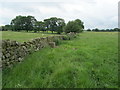
Monk Wall near Dinmore House
Described on the map as "Monk Wall (course of)" - obviously not the original, but on the old foundations of a stone wall with connections to Fountains Abbey.
Image: © Chris Heaton
Taken: 4 Jul 2012
0.14 miles
7
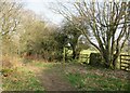
Path leading off Tinkler Lane
Tinkler Lane is no more than a bridleway in appearance, but is shown as one of those 'other routes with public access' on the OS map. One suspects that this is an ancient way as it heads down towards New Bridge which is on an old packhorse route. The signpost points along footpath number 15.55/97 to Dinmore House.
Image: © Gordon Hatton
Taken: 22 Mar 2022
0.15 miles
8
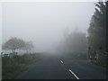
Nidderdale, Burnt Yates, B6165
The pivot benchmark is cut into the top of a field entrance gatepost on the south side of the B6165, and to the west of Burnt Yates.
Image: © Mel Towler
Taken: 1 Aug 2022
0.21 miles
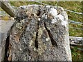
9
Nidderdale, Burnt Yates, B6165
There is a pivot benchmark cut into the top of the left gatepost on the south side of the B6165. This stretch of road is to the west of Burnt Yates.
Image: © Mel Towler
Taken: 1 Aug 2022
0.21 miles