IMAGES TAKEN NEAR TO
Shepherds Thorn Lane, BRIGHOUSE, HD6 3TU
Introduction
This page details the photographs taken nearby to Shepherds Thorn Lane, HD6 3TU by members of the Geograph project.
The Geograph project started in 2005 with the aim of publishing, organising and preserving representative images for every square kilometre of Great Britain, Ireland and the Isle of Man.

There are currently over 7.5m images from over14,400 individuals and you can help contribute to the project by visiting https://www.geograph.org.uk
Image Map
Images are licensed for reuse under creativecommons.org/licenses/by-sa/2.0
Notes
- Clicking on the map will re-center to the selected point.
- The higher the marker number, the further away the image location is from the centre of the postcode.
Image Listing (31 Images Found)
Images are licensed for reuse under creativecommons.org/licenses/by-sa/2.0
Image
Details
Distance
1
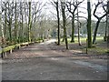
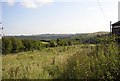
Paths in the Bradley Wood Scout Camp
The waymarked path to the right is along the driveway to Shepherds Thorn Lane. There is also a public footpath straight on, a cul-de-sac due to severance by the M62 motorway.
Image: © Humphrey Bolton
Taken: 4 Mar 2013
0.03 miles
2
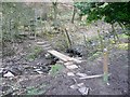
Footbridge over Bradley Park Dike
The bridge is made of two stout baulks of timber.
Image: © Humphrey Bolton
Taken: 4 Mar 2013
0.05 miles
4
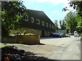
Jubilee Centre
It is a heck of a Scout Hut, but that was the closest category I could find.
The Jubilee Centre, Shepherds Thorn Lane, Brighouse, West Yorkshire, HD6 3TU.
The West Yorkshire Scouts County Campsite, Bradley Wood, is situated between Brighouse and Huddersfield.
It covers an area of about 46 acres - 40 acres of which are natural woodland and the remainder open land.
http://www.wyscouts.org.uk/bradleywood.htm
Image: © Tim Marchant
Taken: 1 Jul 2008
0.10 miles
5
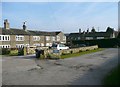
Firth House
Firth House itself is to the right, and is Grade II listed as a handed pair of mid- to late 18C cottages, now one house. It is built of hammer-dressed stone with a stone-slate roof, double pile. The south front has paired doorways with large overlapping lintels and composite jambs, flanked by mullioned windows on both floors. On the right there is a blocked cart entrance and over it a blocked taking-in door.
To the left are early 19C cottages, also Grade II listed, of hammer-dressed stone with a stone slate roof. Each has a doorway with monolithic jambs (that of No. 1 is blocked), and a four-light flat-faced mullioned window.
These descriptions are from the National Heritage List.
Image: © Humphrey Bolton
Taken: 4 Mar 2013
0.11 miles
6
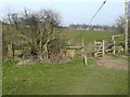
Footpath at Firth House
The footpath goes forward to the electricity pole, where it meets a path from Ryecroft lane to Bradley Wood.
Image: © Humphrey Bolton
Taken: 4 Mar 2013
0.12 miles
7
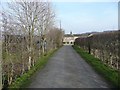
Firth House and Firth House Lane
Firth House is a hamlet that has developed from a (probably) medieval farmstead. The status of the roads leading to such groups of houses varies from one former local authority area to another. In some places roads that lead to more than one property are geverally adopted highways, but in the Calderdale area they tend to be classed as unadopted streets.
Image: © Humphrey Bolton
Taken: 4 Mar 2013
0.13 miles
8
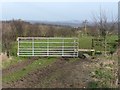
Footpath gate near Firth House
This is at a junction of paths, as indicated by the waymark. The path through the gate leads to Ryecroft Lane. There are some upright slabs of stone on the left.
Image: © Humphrey Bolton
Taken: 4 Mar 2013
0.13 miles
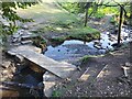
9
Footpath at Firth House, Rastrick
This route from Firth House Lane to Bradley Wood looks to be little used.
Update, March 2013: the path is now clear and easy to use.
Image: © Humphrey Bolton
Taken: 12 Sep 2007
0.14 miles
10
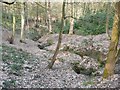
Deep Dike, Bradley Wood
Seen from the public footpath that runs parallel with the motorway. This footpath is a cul-de-sac as a right-of-way, but you can continue to River Street and the canal towpath at Anchor Pit Lock.
Image: © Humphrey Bolton
Taken: 4 Mar 2013
0.14 miles