IMAGES TAKEN NEAR TO
Lords Lane, BRIGHOUSE, HD6 3RF
Introduction
This page details the photographs taken nearby to Lords Lane, HD6 3RF by members of the Geograph project.
The Geograph project started in 2005 with the aim of publishing, organising and preserving representative images for every square kilometre of Great Britain, Ireland and the Isle of Man.

There are currently over 7.5m images from over14,400 individuals and you can help contribute to the project by visiting https://www.geograph.org.uk
Image Map
Images are licensed for reuse under creativecommons.org/licenses/by-sa/2.0
Notes
- Clicking on the map will re-center to the selected point.
- The higher the marker number, the further away the image location is from the centre of the postcode.
Image Listing (361 Images Found)
Images are licensed for reuse under creativecommons.org/licenses/by-sa/2.0
Image
Details
Distance
2
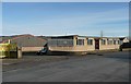
The Avocet offices, Birds Royd Lane, Rastrick
Avocet make dyes and chemicals in the factory behind the offices.
Image: © Humphrey Bolton
Taken: 17 Dec 2010
0.03 miles
3
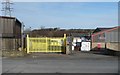
Gate across the former Pollard Street, Rastrick
On the 1907 1:2500 map a block of ten back-to-back houses are shown on Pollard Street, and some terrace houses shown along Birds Royd Lane to the right.
Image: © Humphrey Bolton
Taken: 17 Dec 2010
0.03 miles
4
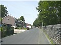
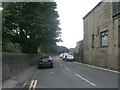
Lord's Lane, Rastrick
This road seems to have been made when the railway was constructed alongside c.1840. By 1859 the only development along the road was Crossley Street.
Image: © Humphrey Bolton
Taken: 15 Aug 2008
0.03 miles
5
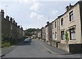
Crossley Street, Rastrick
The houses on the left are on the 1850 OS map, but with only a very narrow street. The wide street and the houses on the right were shown on the 1907 map but not the one of c.1895.
Image: © Humphrey Bolton
Taken: 15 Aug 2008
0.03 miles
6
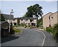
Newlands Close, Rastrick
When the houses on the west side of Crossley Street were built around 1900, a gap was left to give access to a triangular field behind. This was duly developed as Newlands Close in the late 20C (Newlands was the name of the field, or rather of a series of fields on the east side of Huddersfield Road).
Image: © Humphrey Bolton
Taken: 15 Aug 2008
0.03 miles
7
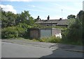
Lockup garages, Crossley Street, Rastrick
The old maps suggest that there were houses on this site, but they had been pulled down by 1907, and it seems strange that the site has not yet been redeveloped.
Image: © Humphrey Bolton
Taken: 15 Aug 2008
0.03 miles
8
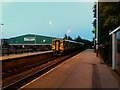
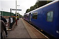
Evening departure from Brighouse station
As the light fades on a midsummer evening, the 21.18 Leeds to Huddersfield (via Halifax) local service, operated by a class 158 Sprinter, pulls out of Brighouse at 22.08.
Image: © Stephen Craven
Taken: 22 Jun 2016
0.05 miles
9
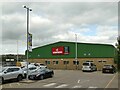
Howdens, Brighouse
Built on the site of the original railway goods shed, this is a branch of a national chain of kitchen wholesalers.
Image: © Stephen Craven
Taken: 4 Jul 2022
0.05 miles