IMAGES TAKEN NEAR TO
Carr Mount/Scrog Lane, HUDDERSFIELD, HD5 0PD
Introduction
This page details the photographs taken nearby to Carr Mount/Scrog Lane, HD5 0PD by members of the Geograph project.
The Geograph project started in 2005 with the aim of publishing, organising and preserving representative images for every square kilometre of Great Britain, Ireland and the Isle of Man.

There are currently over 7.5m images from over14,400 individuals and you can help contribute to the project by visiting https://www.geograph.org.uk
Image Map
Images are licensed for reuse under creativecommons.org/licenses/by-sa/2.0
Notes
- Clicking on the map will re-center to the selected point.
- The higher the marker number, the further away the image location is from the centre of the postcode.
Image Listing (26 Images Found)
Images are licensed for reuse under creativecommons.org/licenses/by-sa/2.0
Image
Details
Distance
1
Footpath eastwards from Carr Mount, Kirkheaton
This footpath goes via Lower Stone Royd to Healey Green Lane, skirting around Hutchin Wood.
Image: © Humphrey Bolton
Taken: 28 Feb 2021
0.04 miles
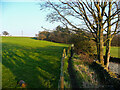
2
Footpath on lane to Carr Mount
Carr Mount is an old row of houses, shown on the 1850 map. The central one has a long row of weaver's windows on the first floor.
Image: © Humphrey Bolton
Taken: 28 Feb 2021
0.06 miles
3
Footpath junction near Carr Mount, Kirkheaton
The path to Carr Mount goes to the left and joins a private lane to Carr Mount. The lane continues to Bellstring Lane but not as a public right-of-way. The path straight on goes to Hagg Farm.
Image: © Humphrey Bolton
Taken: 28 Feb 2021
0.09 miles
4
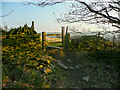
Stile on the footpath approaching Carr Mount from the west
Image: © Humphrey Bolton
Taken: 28 Feb 2021
0.10 miles
5
Footpath approaching a stile, Kirkheaton
The stile, shown in Image, is nicely silhouetted against the sky from the west, but not quite as easy to see from the other direction.
Image: © Humphrey Bolton
Taken: 28 Feb 2021
0.10 miles
6
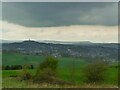
View towards Castle Hill
Looking from the hillside above Kirkheaton, about 5km away. On the distant skyline is the distinctive saddle shape of Deer Hill.
Image: © Stephen Craven
Taken: 14 Apr 2022
0.10 miles
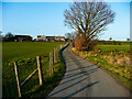
7
Lane to Carr Mount, Kirkheaton
The lane ended somewhere near here in the 19C, and becomes a driveway to a pair of houses, built in the 20C. The public footpath on the lane goes to the right on its original route.
Image: © Humphrey Bolton
Taken: 28 Feb 2021
0.12 miles
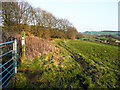
8
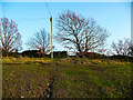
Ploughed field off Bellstring Lane, Kirkheaton
Most of the higher land in this area is pasture, but some is cultivated, often for oil-seed rape. Bellstring Lane refers to the lines of packhorses that used this ancient ridge route from Pontefract to Elland. In the background is Castle Hill, with the Jubilee Tower on top, and behind that the high Pennine ridge
Image: © Humphrey Bolton
Taken: 10 Oct 2005
0.16 miles
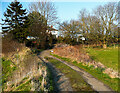
9
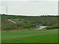
Haul road below Bellstring Lane
A private road belonging to demolition contractor Thomas Crompton, built to access an old clay pit which is gradually being filled.
Image: © Stephen Craven
Taken: 14 Apr 2022
0.18 miles
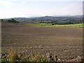
10
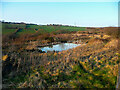
Small pond near a footpath, Kirkheaton
This is the lower of a row of four ponds in what appears to be derelict farmland.
Image: © Humphrey Bolton
Taken: 28 Feb 2021
0.18 miles