IMAGES TAKEN NEAR TO
Hart Street, HUDDERSFIELD, HD4 6LS
Introduction
This page details the photographs taken nearby to Hart Street, HD4 6LS by members of the Geograph project.
The Geograph project started in 2005 with the aim of publishing, organising and preserving representative images for every square kilometre of Great Britain, Ireland and the Isle of Man.

There are currently over 7.5m images from over14,400 individuals and you can help contribute to the project by visiting https://www.geograph.org.uk
Image Map
Images are licensed for reuse under creativecommons.org/licenses/by-sa/2.0
Notes
- Clicking on the map will re-center to the selected point.
- The higher the marker number, the further away the image location is from the centre of the postcode.
Image Listing (102 Images Found)
Images are licensed for reuse under creativecommons.org/licenses/by-sa/2.0
Image
Details
Distance
3
Newsome Mills
For generations a major local landmark. I'm saddened to hear that most of the site is to be demolished with only retention of the tower (and possibly the rest of the multistorey block?). The satellite shows a large area of sheds and they nearly always go to make way for houses. The chimney was offed a few years ago. I wonder if I could get such a car-less view today.
Image: © Chris Allen
Taken: 1 May 1988
0.05 miles
4
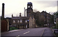
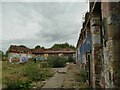
Exterior of Newsome Mills
The mill was founded by John Taylor in 1827, but most buildings on the site dated from c.1873 (the company by then being Taylor and Littlewood). The site once occupied about a hectare on this west side of the road, along with ancillary buildings and a pair of mill ponds the other side.
The mill was listed grade II in 1978 but closed in 1983, and the site was sold in 2006 (from listing description, ref. 1232037). Most of the buildings were still standing when photographed for this site in 2010 Image but were severely damaged by a fire on 17 November 2016. Following works in 2019 to make the site safe, only the ground floor walls of one section of the building remain, along with the clock tower Image and entrance arch Image https://www.examinerlive.co.uk/news/west-yorkshire-news/fire-gutted-newsome-mills-site-15733756
The site is earmarked for housing but no development has been started yet.
Image: © Stephen Craven
Taken: 25 Sep 2022
0.05 miles
6
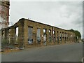
Interior of Newsome Mills
The mill was founded by John Taylor in 1827, but most buildings on the site dated from c.1873 (the company by then being Taylor and Littlewood). The site once occupied about a hectare on this west side of the road, along with ancillary buildings and a pair of mill ponds the other side.
The mill was listed grade II in 1978 but closed in 1983, and the site was sold in 2006 (from listing description, ref. 1232037). Most of the buildings were still standing when photographed for this site in 2010 Image but were severely damaged by a fire on 17 November 2016. Following works in 2019 to make the site safe, only the ground floor walls of one section of the building remain, along with the clock tower Image and entrance arch Image https://www.examinerlive.co.uk/news/west-yorkshire-news/fire-gutted-newsome-mills-site-15733756
The site is earmarked for housing but no development has been started yet.
Image: © Stephen Craven
Taken: 25 Sep 2022
0.05 miles
9
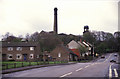
Newsome Mills
At the top of the steep hill known variously as Lockwood Scar or Taylor Hill. This site with its chimney was visible from far and wide but the chimney has gone.
Image: © Chris Allen
Taken: 1 May 1988
0.06 miles
10
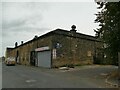
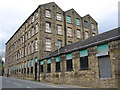
Building opposite Newsome Mills
The building on Ruth Street was obviously part of the mill complex, sitting as it does between the now-ruined main building and the mill pond that still exists behind it. It appears to be something of a small business centre now.
The road to the right is Naomi Road, which shows the street naming to have a Biblical reference, as Naomi was Ruth's mother-in-law in the Bible.
Image: © Stephen Craven
Taken: 25 Sep 2022
0.06 miles