IMAGES TAKEN NEAR TO
Whitehead Lane, HUDDERSFIELD, HD4 6AS
Introduction
This page details the photographs taken nearby to Whitehead Lane, HD4 6AS by members of the Geograph project.
The Geograph project started in 2005 with the aim of publishing, organising and preserving representative images for every square kilometre of Great Britain, Ireland and the Isle of Man.

There are currently over 7.5m images from over14,400 individuals and you can help contribute to the project by visiting https://www.geograph.org.uk
Image Map
Images are licensed for reuse under creativecommons.org/licenses/by-sa/2.0
Notes
- Clicking on the map will re-center to the selected point.
- The higher the marker number, the further away the image location is from the centre of the postcode.
Image Listing (123 Images Found)
Images are licensed for reuse under creativecommons.org/licenses/by-sa/2.0
Image
Details
Distance
1
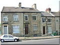
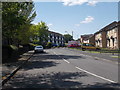
Primrose Hill, Huddersfield
This view of Whitehead Lane shows No. 144 which was a bakery for 40 years (1915-1955) and was run throughout that time by Fred Copley.
Image: © Andrew Loughran
Taken: 9 May 2006
0.02 miles
2
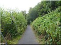
Riverside Path
A named route along the Rivers Holme and Colne. Here the path has moved away from the bank of the River Holme to go around the site of an old concrete works and join Queens Mill Road further ahead.
Image: © Kevin Waterhouse
Taken: 27 Aug 2024
0.06 miles
3
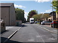
Orchard Street - Primrose Hill Road
Image: © Betty Longbottom
Taken: 24 May 2016
0.07 miles
4
Armitage Street - Primrose Hill Road
Image: © Betty Longbottom
Taken: 24 May 2016
0.08 miles
5
Perseverance Street - Primrose Hill Road
Image: © Betty Longbottom
Taken: 24 May 2016
0.09 miles
6
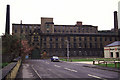
Albert Mill
A wider view but partly obscured by Magnet Southerns.
Image: © Chris Allen
Taken: 1 May 1988
0.10 miles
7
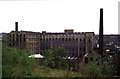
Albert Mills
Seen from round the back of Primrose Hill. There is a secluded path runs along the River Holme behind the mills. It run between Lockwood Scar and Queens Mill Road and I really must walk it again.
Image: © Chris Allen
Taken: 1 May 1988
0.10 miles
8
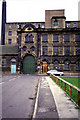
Albert Mills from Summer Street.
Established 1853 as a woollen mill. Includes 6 storey fireproof mill with 15 bays and internal end engine house - 3 storeys for beam engine. There is an attached boiler house with drying floors over. The front block with gate and dyehouse to left has a datestone stating 1853 but is actually from 1871. There is a small weaving shed at the back against the river. A very nice complex but I don't know its current status. There were also good views from the river side but tree growth might have ruined those.
Image: © Chris Allen
Taken: 6 Dec 1987
0.10 miles
9
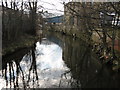
River Holme viewed from Queens Mill Road
Looking south west.
Image: © Stephen Armstrong
Taken: 10 Mar 2010
0.12 miles
10
Industrial Street - Primrose Hill Road
Image: © Betty Longbottom
Taken: 24 May 2016
0.12 miles