IMAGES TAKEN NEAR TO
Lindley Moor Road, HUDDERSFIELD, HD3 3TE
Introduction
This page details the photographs taken nearby to Lindley Moor Road, HD3 3TE by members of the Geograph project.
The Geograph project started in 2005 with the aim of publishing, organising and preserving representative images for every square kilometre of Great Britain, Ireland and the Isle of Man.

There are currently over 7.5m images from over14,400 individuals and you can help contribute to the project by visiting https://www.geograph.org.uk
Image Map
Images are licensed for reuse under creativecommons.org/licenses/by-sa/2.0
Notes
- Clicking on the map will re-center to the selected point.
- The higher the marker number, the further away the image location is from the centre of the postcode.
Image Listing (40 Images Found)
Images are licensed for reuse under creativecommons.org/licenses/by-sa/2.0
Image
Details
Distance
1
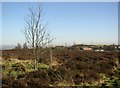
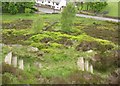
Recreation ground, Old Lindley Moor
Captioned thus on the 6 inch map of c.1940, but shown as rough pasture so it was probably never an informal sports ground.
Image: © Humphrey Bolton
Taken: 12 Feb 2008
0.02 miles
2
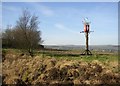
Mystery object, Old Lindley Moor
At first I took this to be a beacon, but it is too decorative on top. Why the Swiss cross?
Image: © Humphrey Bolton
Taken: 12 Feb 2008
0.02 miles
3
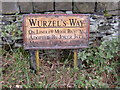
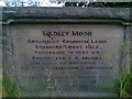
Sign on Old Lindley Moor, Old Lindley
Above the steep escarpment of old Lindley Moor is a flat-topped ridge. This was transferred to Huddersfield CB in 1913, and part of it became a cricket ground, part a 'crippled children's home' and part a 'recreation ground' (as on a 6” map of c.1930). This latter is an area of heather with a driveway to a superb viewpoint. This sign is by the side of the driveway.
Image: © Humphrey Bolton
Taken: 15 Oct 2007
0.02 miles
4
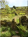
Footpath up to Old Lindley Edge Recreation Ground
The stile is at Old Lindley Road.
Image: © Humphrey Bolton
Taken: 27 May 2006
0.04 miles
5
Footpath down from Old Lindley Edge
Old Lindley Road is at the bottom. This hillside was transferred from Stainland and Old Lindley UD to Huddersfield County Borough when the UD was abolished in 1937. There was a recreation ground at the top, still apparently a public open space, and also a 'Crippled Children's Home'. It would seem likely that the zigzag steps were made at the same time as the recreation ground.
Image: © Humphrey Bolton
Taken: 27 May 2006
0.04 miles
6
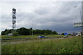
The M62 on Old Lindley Moor
Between Junctions 23 & 24, where there are good views on the far side.
Image: © Bill Boaden
Taken: 26 Jun 2013
0.05 miles
7
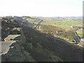
Old Lindley Edge
View along the edge. In the foreground one of a series of outcrops of sandstone. Behind, in SE0918, a bridleway goes along the foot of the escarpment to Outlane. On the right Old Lindley Road leads to the hamlet of that name.
Image: © Humphrey Bolton
Taken: 12 Feb 2008
0.07 miles
8
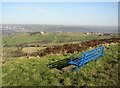
Seat with a view, Old Lindley Edge
The Baptist chapel and derelict brickworks can be seen on the ridge at Blackley. The green valley in front of them used to be a tip, but appears now to be reinstated.
Image: © Humphrey Bolton
Taken: 12 Feb 2008
0.07 miles
10
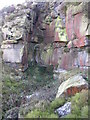
Part of Old Lindley Quarry
Lindley Quarry is an important geological site, where, to quote from the West Yorkshire Geology Trust's website, “Rough Rock sandstones of the Carboniferous Age (Namurian Epoch) are exposed along a 50 metre abandoned quarry face. The exposure contains a range of sedimentary structures and plant fossils. Towards the eastern end of the exposure a section of exceptionally well preserved sets of cross bedding can be seen. The exposure allows the mineralogy and texture of Rough Rock strata to be studied.” Hoar frost on the grass of the steep hillside meant that I only reached this small quarry face to the east of the main site, and I assume that this is Rough rock sandstone.
Image: © Humphrey Bolton
Taken: 12 Feb 2008
0.08 miles