IMAGES TAKEN NEAR TO
Red Doles Lane, HUDDERSFIELD, HD2 1YF
Introduction
This page details the photographs taken nearby to Red Doles Lane, HD2 1YF by members of the Geograph project.
The Geograph project started in 2005 with the aim of publishing, organising and preserving representative images for every square kilometre of Great Britain, Ireland and the Isle of Man.

There are currently over 7.5m images from over14,400 individuals and you can help contribute to the project by visiting https://www.geograph.org.uk
Image Map (Loading...)


Getting Data...Please wait
Leaflet Map data © OpenStreetMap
Images are licensed for reuse under creativecommons.org/licenses/by-sa/2.0
Notes
- Clicking on the map will re-center to the selected point.
- The higher the marker number, the further away the image location is from the centre of the postcode.
Image Listing (58 Images Found)
Images are licensed for reuse under creativecommons.org/licenses/by-sa/2.0
Image
Details
Distance
1
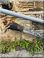
Cut Mark - Mill - Canker Lane - Huddersfield (b)
Partially obscured cut mark on side of Mill building on Canker Lane, Huddersfield
Image: © Tez Exley
Taken: 1 Apr 2023
0.04 miles
2
Cut Mark - Mill - Canker Lane - Huddersfield (c)
Partially obscured cut mark on side of Mill building on Canker Lane, Huddersfield
Image: © Tez Exley
Taken: 1 Apr 2023
0.04 miles
3
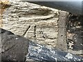
Cut Mark - Mill - Canker Lane - Huddersfield (a)
Partially obscured cut mark on side of Mill building on Canker Lane, Huddersfield
Image: © Tez Exley
Taken: 1 Apr 2023
0.04 miles
4
Red Doles Lane, Fartown, Huddersfield
Not a pretty lane, but a very useful short cut for cyclists between Fartown Green and Leeds Road. At the bend the status mysteriously changes on the OS map from byway to footpath, but this has no practical significance.
Image: © Humphrey Bolton
Taken: 21 Mar 2007
0.06 miles
5
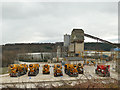
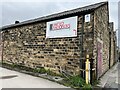
Readymix Huddersfield, Red Doles Lane
When I worked on construction sites in this area in the 1980s and 90s, this was the main supplier of ready mixed concrete, and they're still going under the same name.
Image: © Stephen Craven
Taken: 25 Jan 2020
0.09 miles
6
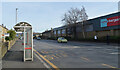
Bus shelter, Leeds Road (A62), Huddersfield
Image: © habiloid
Taken: 8 Feb 2023
0.10 miles
7
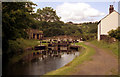
Fartown Green, or Red Doles, Lock No 9, Huddersfield Broad Canal
This is the highest of the nine locks on the Huddersfield Broad, or Sir John Ramsden's, canal. They were built to take Yorkshire keels or short boats, with dimensions not exceeding 58ft x 14ft 2ins. Hand spikes, rather than a windlass, were used to raise the paddles on many of these locks.
Image: © Dr Neil Clifton
Taken: 19 Jun 1993
0.11 miles
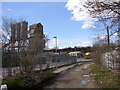
9
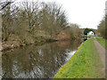
View eastwards towards lock 9, Huddersfield Broad Canal
The lock is listed grade II (list entry 1290603), where it is dated 1774-80.
Image: © Stephen Craven
Taken: 25 Jan 2020
0.13 miles
10
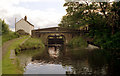
Red Doles Bridge 11, Huddersfield Broad Canal
This minor bridge, which adjoins to top lock, carries a footpath with public right of way. Viewed here from the north-east
Image: © Dr Neil Clifton
Taken: 19 Jun 1993
0.13 miles