IMAGES TAKEN NEAR TO
Croset Avenue, HUDDERSFIELD, HD1 6SE
Introduction
This page details the photographs taken nearby to Croset Avenue, HD1 6SE by members of the Geograph project.
The Geograph project started in 2005 with the aim of publishing, organising and preserving representative images for every square kilometre of Great Britain, Ireland and the Isle of Man.

There are currently over 7.5m images from over14,400 individuals and you can help contribute to the project by visiting https://www.geograph.org.uk
Image Map
Images are licensed for reuse under creativecommons.org/licenses/by-sa/2.0
Notes
- Clicking on the map will re-center to the selected point.
- The higher the marker number, the further away the image location is from the centre of the postcode.
Image Listing (96 Images Found)
Images are licensed for reuse under creativecommons.org/licenses/by-sa/2.0
Image
Details
Distance
1
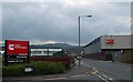
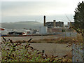
Turbo Technologies junction Croset Ave. and St Andrews Road
Formerly Holset Engineering. The grey building on the right is a steel framed North Light Structure. Castle Hill is in the background.
Image: © Steve Fareham
Taken: 27 Apr 2008
0.09 miles
2
Riverside Path at abandoned car park
A named route along the banks of Rivers Holme and Colne. Here the path has left the River Colne and reached a former car park south of the John Smith's Stadium and the path will regain the riverside at Stadium Way.
Image: © Kevin Waterhouse
Taken: 27 Aug 2024
0.09 miles
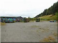
3
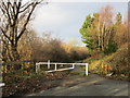
Gate on Kilner Bank
The central part of Kilner Bank is closed to traffic.
Image: © Jonathan Thacker
Taken: 14 Jan 2016
0.11 miles
4
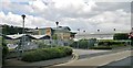
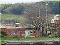
Cummins Turbo Technologies
Just part of a vast site, one of the biggest employers in Huddersfield
Image: © Chris Morgan
Taken: 24 Jul 2013
0.11 miles
5
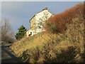
House on Kilner Bank
Looks out across the Colne Valley.
Image: © Jonathan Thacker
Taken: 14 Jan 2016
0.13 miles
6
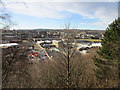
View across the Colne Valley
Industry and commercial activity is concentrated in the valley bottom with residential areas on the surrounding hills.
Image: © Jonathan Thacker
Taken: 14 Jan 2016
0.13 miles
7
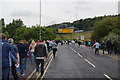
Walking to the Galpharm Stadium
The road crosses the River Colne just here.
Image: © Bill Boaden
Taken: 6 Aug 2011
0.15 miles
8
Tow path graffiti
Graffiti alongside the Huddersfield Broad Canal.
Image: © Steve Fareham
Taken: 27 Apr 2008
0.15 miles
9
Former gasworks, Huddersfield
The site to the south of Gasworks Street was opened in 1822 and by the time of the 1907 OS map held two gasholders, later replaced by three others on this side of the road and a larger one to the north that still survives Image It is now vacant, presumably awaiting development by any developer willing to take on the cost of remediating polluted land.
Image: © Stephen Craven
Taken: 25 Jan 2020
0.16 miles
10
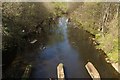
River Colne near Stadium Way
I am unsure what the supports in the foreground were used for. Perhaps electricity or gas? Further along the river on the right-hand side, there is a stone support for an old bridge shown on the Ordnance Survey Six Inch 1888 - 1913 map.
Image: © Mark Anderson
Taken: 20 Apr 2019
0.16 miles