IMAGES TAKEN NEAR TO
Mead Street, HUDDERSFIELD, HD1 6HE
Introduction
This page details the photographs taken nearby to Mead Street, HD1 6HE by members of the Geograph project.
The Geograph project started in 2005 with the aim of publishing, organising and preserving representative images for every square kilometre of Great Britain, Ireland and the Isle of Man.

There are currently over 7.5m images from over14,400 individuals and you can help contribute to the project by visiting https://www.geograph.org.uk
Image Map
Images are licensed for reuse under creativecommons.org/licenses/by-sa/2.0
Notes
- Clicking on the map will re-center to the selected point.
- The higher the marker number, the further away the image location is from the centre of the postcode.
Image Listing (155 Images Found)
Images are licensed for reuse under creativecommons.org/licenses/by-sa/2.0
Image
Details
Distance
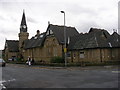
1
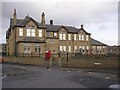
School, Mead Street, Fartown, Huddersfield
Some of these 19C schools are quite extensive, with several linked buildings. This was built as a Central (later Secondary Technical) School.
Image: © Humphrey Bolton
Taken: 23 Feb 2007
0.03 miles
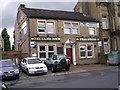
3
Fartown Conservative Club - Halifax Old Road
Image: © Betty Longbottom
Taken: 18 Aug 2008
0.05 miles
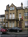
5
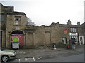
Remains of Fitton's Yard
The frontage to Halifax Old Road must once have been quite a handsome building.
Image: © Jonathan Thacker
Taken: 28 Mar 2014
0.05 miles
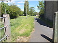
6
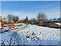
Bradley Birkby Greenway
Before the construction of the library
Image: © yorkshirelad
Taken: 15 Jan 2021
0.06 miles
7
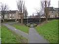
The Back Honoria Street bridge, Fartown cycleway, Huddersfield
The Honoria Street bridge, out of sight, is a girder bridge like the others, but for some reason this bridge is arched. This railway was constructed in the early 20C (it is not on the map of 1907) to give the Midland Railway Company an alternative route to London, rather than paying for running rights on the London and North West Railway line. They intended to build a terminal station at Newtown near St John's Road, but the First World War intervened and a goods yard was constructed instead, now redeveloped as a retail and business park. As with human redundancy, it was 'last in, first out'. Several houses had to be demolished to build the line across these streets.
Image: © Humphrey Bolton
Taken: 23 Feb 2007
0.06 miles
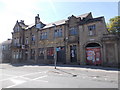
10
Birkby & Fartown Community Centre - Wasp Nest Road
Image: © Betty Longbottom
Taken: 18 Aug 2008
0.07 miles