IMAGES TAKEN NEAR TO
Wakefield Road, HUDDERSFIELD, HD1 3AQ
Introduction
This page details the photographs taken nearby to Wakefield Road, HD1 3AQ by members of the Geograph project.
The Geograph project started in 2005 with the aim of publishing, organising and preserving representative images for every square kilometre of Great Britain, Ireland and the Isle of Man.

There are currently over 7.5m images from over14,400 individuals and you can help contribute to the project by visiting https://www.geograph.org.uk
Image Map
Images are licensed for reuse under creativecommons.org/licenses/by-sa/2.0
Notes
- Clicking on the map will re-center to the selected point.
- The higher the marker number, the further away the image location is from the centre of the postcode.
Image Listing (286 Images Found)
Images are licensed for reuse under creativecommons.org/licenses/by-sa/2.0
Image
Details
Distance
1
Former canal warehouse, Aspley
Allegedly one of the oldest canal warehouses in the country and now converted to accommodation. Here is an earlier view of the same building but from a different angle - Image
Image: © Chris Allen
Taken: 17 Aug 2002
0.00 miles
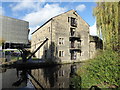
2
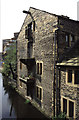
John Ramsden Court, Huddersfield Broad Canal
This Warehouse is thought to be one of the oldest surviving warehouses of its type in Great Britain and is possibly the oldest building in Huddersfield town centre (http://huddersfieldhistory.files.wordpress.com/2009/03/the-buildings-of-huddersfield-reprint-2009-sources1.pdf David Wyles, "The Buildings of Huddersfield"). It was erected ca1776 by Sir John Ramsden for storing wool and is indicated on a 1778 survey map. There are taking‑in doors on four levels and the remains of a winch system on the top floor. The right hand wing was added between 1780 and 1825; it was originally longer but was truncated when the Wakefield Road was widened in the 1960's. The warehouse is a Grade II* listed building (English Heritage Building ID: 419740 http://www.britishlistedbuildings.co.uk/en-419740-canal-warehouse-at-aspley-basin- British Listed Buildings).
The Crane adjacent to the warehouse has a base of cast iron with a wooden jib. A heavy stone counter balances the weight of the jib.
The warehouse has now been converted into luxury flats.
Image: © David Dixon
Taken: 5 Jan 2015
0.01 miles
3
Huddersfield Narrow Canal
Alongside main campus of Huddersfield University
Image: © Michael Westley
Taken: 24 Sep 2011
0.01 miles
4
Huddersfield Narrow Canal and a converted warehouse
The building on the left is part of the University. The warehouse dates from c1780 and is in hammer dressed stone with a stone slate roof. The balconies are on former canal side loading doors. I first photographed this when it was derelict. It has now been converted to apartments.
Image: © Chris Allen
Taken: 2 Nov 2017
0.01 miles
6
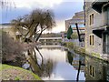
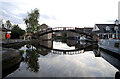
Huddersfield Broad Canal, South of Wakefield Road
The section of the Huddersfield Broad Canal between Wakefield Road Bridge and Lock 1 of the Narrow Canal was restored and landscaped as part of the re-development of the area for the University. However, following strengthening work to Wakefield Road which included the construction of a reinforced concrete tunnel under the original bridge in the 1970s, this short section has been inaccessible from the rest of the Broad Canal and is only navigable to vessels whose width is less than 7 feet (narrowboats).
This view is looking south, from the towpath at Wakefield Road.The building to the right is the former warehouse detailed in Image Ahead is the Poly footbridge connecting parts of the University campus as shown in Image
Image: © David Dixon
Taken: 5 Jan 2015
0.02 miles
7
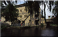
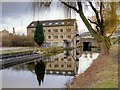
Converted warehouse, Aspley
This former warehouse and preserved crane are alongside the restored Huddersfield Narrow Canal. The bridge in the background carries a main road out of Huddersfield and its reinstatement was a major piece of enabling work. Beyond it is the Aspley Basin which is also the start of the Broad Canal (Sir John Ramsden's Canal).
Image: © Chris Allen
Taken: 17 Aug 2002
0.03 miles

9
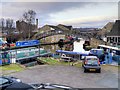
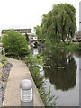
Aspley Wharf Marina, Huddersfield Broad Canal
For over 150 years, Aspley Basin was one of the busiest places in Huddersfield. It came into being when the Broad Canal was completed and greatly increased in importance once the Narrow Canal was finished in 1811. The site was laid out with wharves, cranes and housing for canal workers creating a small dockland. It was a flourishing place because goods had to be transhipped here from the Broad Canal barges to narrowboats and vice versa as the barges were too wide to use the Narrow Canal and the narrowboats were too long to pass through the short locks on the Broad Canal. Today, the basin has been made into a small marina.
Image: © David Dixon
Taken: 5 Jan 2015
0.03 miles