IMAGES TAKEN NEAR TO
St. Johns Close, WEMBLEY, HA9 7JE
Introduction
This page details the photographs taken nearby to St. Johns Close, HA9 7JE by members of the Geograph project.
The Geograph project started in 2005 with the aim of publishing, organising and preserving representative images for every square kilometre of Great Britain, Ireland and the Isle of Man.

There are currently over 7.5m images from over14,400 individuals and you can help contribute to the project by visiting https://www.geograph.org.uk
Image Map
Images are licensed for reuse under creativecommons.org/licenses/by-sa/2.0
Notes
- Clicking on the map will re-center to the selected point.
- The higher the marker number, the further away the image location is from the centre of the postcode.
Image Listing (142 Images Found)
Images are licensed for reuse under creativecommons.org/licenses/by-sa/2.0
Image
Details
Distance
1
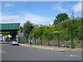
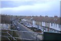
The Chiltern Line in Wembley
On 20th November 1905 the Great Central Railway opened a new route for freight trains between Neasden Junction and Northolt Junction, and on 1st March 1906 passenger services began from High Wycombe to the Great Central's then new terminus at Marylebone. The line was built though open country, yet impressive stations were provided. However, passengers tended to opt for the parallel (now Piccadilly) line, and by 1968 the service was said to be the sparsest in London. Plans were afoot to close it between Neasden and Northolt and direct trains into Paddington, but the line has survived.
Here the Chiltern Line crosses St John's Road in Wembley.
Image: © Marathon
Taken: 15 Jul 2015
0.05 miles
2
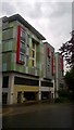
Pure Gym and block of flats
As seen from Elm Road. The Gym takes the ground and first floors.
Image: © David Anstiss
Taken: 18 Jun 2019
0.06 miles
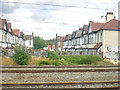
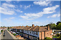
4
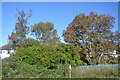
Acacia Avenue
This very short road and 2 rows of houses leads from St John's Road.
At the end is the Bakerloo Line railway line between Wembley Central and North Wembley, also railway services on London Overground use tracks.
Image: © David Anstiss
Taken: 18 Jun 2019
0.06 miles
5
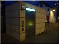
Wembley: talking toilet in Elm Road Car Park
This toilet costs 10p to use and, once inside, a female voice gives you full instructions on how to lock the door and operate the water, soap and hot air facilities. On your unlocking the door she wishes you a good day.
Image: © Chris Downer
Taken: 9 Jul 2011
0.06 miles
6
London Borough of Brent : West Coast Main Line
Acacia Avenue can be seen beyond the tracks.
Image: © Lewis Clarke
Taken: 18 Jul 2019
0.07 miles
7
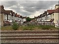
Acacia Avenue, Wembley
From the railway.
Image: © Andrew Abbott
Taken: 5 Jun 2019
0.08 miles
8
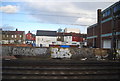
North Wembley, by the West Coast Main Line
Image: © N Chadwick
Taken: 18 Dec 2011
0.08 miles
10
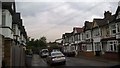
St John's Road, Wembley
Looking NNW along St. John's Road from the railway bridge.
Image: © David P Howard
Taken: 13 Apr 2014
0.09 miles