IMAGES TAKEN NEAR TO
Derek Avenue, WEMBLEY, HA9 6HP
Introduction
This page details the photographs taken nearby to Derek Avenue, HA9 6HP by members of the Geograph project.
The Geograph project started in 2005 with the aim of publishing, organising and preserving representative images for every square kilometre of Great Britain, Ireland and the Isle of Man.

There are currently over 7.5m images from over14,400 individuals and you can help contribute to the project by visiting https://www.geograph.org.uk
Image Map
Images are licensed for reuse under creativecommons.org/licenses/by-sa/2.0
Notes
- Clicking on the map will re-center to the selected point.
- The higher the marker number, the further away the image location is from the centre of the postcode.
Image Listing (87 Images Found)
Images are licensed for reuse under creativecommons.org/licenses/by-sa/2.0
Image
Details
Distance
1
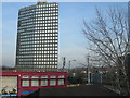
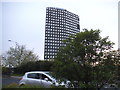
Wembley Point, Stonebridge Park
Photo taken from Stonebridge Park Station. This is a distinctive landmark at the junction of the A406 North Circular Road and the A404 Paddington to Harrow Road.
Image: © Danny P Robinson
Taken: 4 Feb 2007
0.06 miles
2
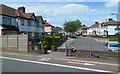
Tokyngton Avenue, Tokyngton
The SE end of Tokyngton Avenue is at railings alongside Point Place.
Image: © Jaggery
Taken: 13 May 2012
0.06 miles

5
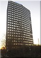
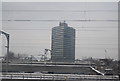
Wembley Point, Stonebridge Park
Originally called Station House, the building is now taking advantage of the new law allowing business premises to convert to residential. Many blocks around London are now evicting its businesses and becoming blocks of flats, including Premier House, the old Green Shield offices in Edgware, and the block on the corner of Kew Bridge.
Image: © David Howard
Taken: 29 Dec 2016
0.07 miles
6
Wembley Point from Harrow Road
It used to be Station House till the 90s. I went up it once in the 80s to make a delivery from work.
Image: © David Howard
Taken: 30 Apr 2018
0.07 miles
7
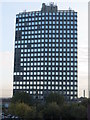
Wembley Point at Stonebridge Park
Nearly 80m high, 21 floors and built in 1963-5, this skyscraper office block a triangular in plan. It was designed by Covell, Matthews and Partners.
Image: © Richard Rogerson
Taken: 21 Oct 2011
0.07 miles
8
Wembley Point
A modern office block. http://www.wembleypointlondon.com/
Image: © N Chadwick
Taken: 19 Dec 2010
0.07 miles
9
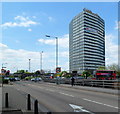
Wembley Point office block, London
Viewed across the North Circular Road from the corner of Durand Way.
The 80 metre (262ft) high triangular building was constructed in 1963-1965 in what was later known as the Brutalist style - usually characterised by a predominance of concrete, very linear, blockish and like a fortress. To this non-architect, Wembley Point seems to be a less severe example of its type. A more severe example is Trelleck Tower. http://www.geograph.org.uk/photo/2774590
Image: © Jaggery
Taken: 13 May 2012
0.07 miles
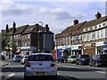
10
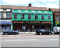
The Innisfree, Tokyngton
Pub at 30-32 Harrow Road.
On researching this location, I noticed that, while still in London, I had left NW10 and the London postal district and entered (in postal terms) the Harrow district. The creation of Greater London in 1965 extended the boundary of London far beyond the London postal district, which was not expanded in step. The changes needed would have been too costly.
Image: © Jaggery
Taken: 13 May 2012
0.07 miles