IMAGES TAKEN NEAR TO
Cumberland Road, STANMORE, HA7 1QH
Introduction
This page details the photographs taken nearby to Cumberland Road, HA7 1QH by members of the Geograph project.
The Geograph project started in 2005 with the aim of publishing, organising and preserving representative images for every square kilometre of Great Britain, Ireland and the Isle of Man.

There are currently over 7.5m images from over14,400 individuals and you can help contribute to the project by visiting https://www.geograph.org.uk
Image Map
Images are licensed for reuse under creativecommons.org/licenses/by-sa/2.0
Notes
- Clicking on the map will re-center to the selected point.
- The higher the marker number, the further away the image location is from the centre of the postcode.
Image Listing (47 Images Found)
Images are licensed for reuse under creativecommons.org/licenses/by-sa/2.0
Image
Details
Distance
2
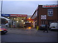
Old garage on corner of Cumberland Road, Queensbury
This used to be a petrol station
Image: © David Howard
Taken: 6 Nov 2008
0.03 miles
3
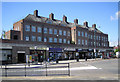
Queensbury Station Parade
The entrance to Queensbury Underground station is in the centre of this building. The Metropolitan Line had already opened their branch line from Wembley Park to Stanmore two years previously when this station was opened in December 1934. The operation of the line passed to the Bakerloo Line in 1939 and finally to the Jubilee Line in 1979.
Image: © Nigel Cox
Taken: 18 May 2007
0.07 miles
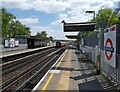
6
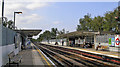
Queensbury station, 2009
View NW, towards Stanmore: London Underground Jubilee Line, formerly Bakerloo line, originally Metropolitan Line, branch from Wembley Park. (For details see Image).
Image: © Ben Brooksbank
Taken: 18 Sep 2009
0.10 miles
7
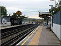
Queensbury station
This station was built by the Metropolitan Railway on their Stanmore branch, but it did not open as early as the other stations on the line as there was, at the time, little development in the area. That soon changed, and the name of the area, Queensbury, was chosen to fit with Kingsbury, the next main settlement. In 1939 when the Bakerloo Line was extended from Baker Street to Finchley Road, it took over the Stanmore branch, so Queensbury became a Bakerloo Line station. But that changed again in 1976 with the coming of the Jubilee Line, which took over that part of the Bakerloo from Baker Street to Stanmore. Jubilee Line trains now operate from Stratford to Stanmore.
Image: © Dr Neil Clifton
Taken: 30 Oct 2015
0.10 miles
8
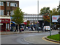
Queensbury: Bridge over Cumberland Road
The bridge carries the London Transport railway, while Cumberland Road is a short link road to the A4140, hence, left to Kingsbury and Neasden, and right to Stanmore and Watford.
Image: © Dr Neil Clifton
Taken: 30 Oct 2015
0.10 miles
10
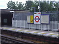
Queensbury Station platform
It wasn't 100% possible to confirm this is the correct side as from the air both views are almost the same, but I do know it is the northbound platform, so if anyone knows which is which then I can confirm it.
Image: © David Howard
Taken: 16 Jul 2008
0.10 miles