IMAGES TAKEN NEAR TO
Pinner Road, PINNER, HA5 5RT
Introduction
This page details the photographs taken nearby to Pinner Road, HA5 5RT by members of the Geograph project.
The Geograph project started in 2005 with the aim of publishing, organising and preserving representative images for every square kilometre of Great Britain, Ireland and the Isle of Man.

There are currently over 7.5m images from over14,400 individuals and you can help contribute to the project by visiting https://www.geograph.org.uk
Image Map
Images are licensed for reuse under creativecommons.org/licenses/by-sa/2.0
Notes
- Clicking on the map will re-center to the selected point.
- The higher the marker number, the further away the image location is from the centre of the postcode.
Image Listing (26 Images Found)
Images are licensed for reuse under creativecommons.org/licenses/by-sa/2.0
Image
Details
Distance
1
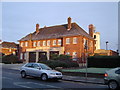
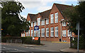
Pinner: Harrow Fire Station
On Pinner Road, but curiously at least 2 kilometres, as the crow flies, from Harrow Civic Centre, the fire station was built in 1937.
Image: © Nigel Cox
Taken: 30 Nov 2005
0.03 miles
2
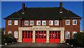
Harrow Fire Station (1937)
Typical understated design of a public service building favoured by inter-war Government architects
Image: © Jim Osley
Taken: 27 Jan 2012
0.03 miles
3
Harrow Fire Station
Built in 1937. Behind,on the right, is the practice tower. The doors have had a repaint since this building was last photographed for Geograph by Nigel Cox in 2005, see - Image
Image: © Martin Addison
Taken: 12 Sep 2009
0.04 miles
4

Old Milestone by Pinner Road, Pinner Parish
Metal plate attached to stone post by the UC road (was A404), in parish of PINNER (HARROW District), Pinner Road, opposite No. 587, to the West of school entrance, in front of sub-station, behind chain link fence, on North side of road. Kilburn plate, erected by the Kilburn Bridge to Sparrow's Herne turnpike trust in the 19th century.
Inscription reads:-
TO
LONDON
12
MILES
Grade II listed. List Entry Number: 1079683
https://historicengland.org.uk/listing/the-list/list-entry/1079683
Milestone Society National ID: MX_LH12.
Image: © C Woodward
Taken: 27 Jul 2009
0.04 miles
5
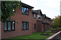
Betjeman Close, Pinner Road
Betjeman Close, a fitting name given that this is Metroland, is a small housing estate built around a cul-de-sac off the Pinner Road. These houses are along the Pinner Road itself.
Image: © Martin Addison
Taken: 12 Sep 2009
0.07 miles
6
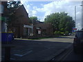
Nower Hill School
Built in 1929, it was known as Headstone School. The school has expanded significantly with modern annexes behind this original building, facing George V Avenue.
Image: © Martin Addison
Taken: 12 Sep 2009
0.08 miles
7
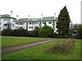
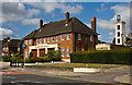
Pinner: Pinner Court, Pinner Road
Pinner Court and its sister block, Capel Gardens, were built in 1935 and 1936 as colonial-style luxury flats, for the Courtenay Property Company Limited, to the design of H J Mark. The distinctive green tile roofed white walled buildings have three stories and are arranged in three groupings set back about 60 metres from Pinner Road. The dark block on the right is a fountain.
Image: © Nigel Cox
Taken: 18 Jan 2008
0.09 miles
9
North Harrow Methodist church, Pinner Road
Image: © David Howard
Taken: 22 Aug 2012
0.13 miles
10
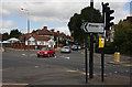
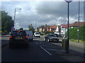
Headstone Lane
Seen from the junction with Pinner Road, on the right, and George V Avenue on the left. The cars coming straight across the junction are joining the Pinner Road which bends sharply left here.
Image: © Martin Addison
Taken: 12 Sep 2009
0.13 miles