IMAGES TAKEN NEAR TO
Woodgrange Close, HARROW, HA3 0XH
Introduction
This page details the photographs taken nearby to Woodgrange Close, HA3 0XH by members of the Geograph project.
The Geograph project started in 2005 with the aim of publishing, organising and preserving representative images for every square kilometre of Great Britain, Ireland and the Isle of Man.

There are currently over 7.5m images from over14,400 individuals and you can help contribute to the project by visiting https://www.geograph.org.uk
Image Map
Images are licensed for reuse under creativecommons.org/licenses/by-sa/2.0
Notes
- Clicking on the map will re-center to the selected point.
- The higher the marker number, the further away the image location is from the centre of the postcode.
Image Listing (58 Images Found)
Images are licensed for reuse under creativecommons.org/licenses/by-sa/2.0
Image
Details
Distance
1
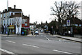
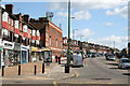
Kenton: Woodgrange Avenue
This road branches away from the south side of Kenton Road near the top of Woodcock Hill, which it immediately crosses and then pursues an easterly course before re-joining Kenton Road about a quarter of a mile further east.
Image: © Dr Neil Clifton
Taken: 1 Apr 2010
0.08 miles
2
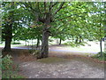
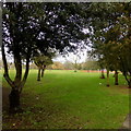
Woodcock Park
Woodcock Park was once part of the grounds of Kenton Grange, which was built as Kenton Lodge at the start of the 19th century with a small garden behind the house. The land was sold in the 1950s to Middlesex County Council who turned Kenton Grange into an old people's home, and the remaining land into a public park. Much of the park is mown grass except alongside the Wealdstone Brook which runs through the centre of the park.
This is close to the north side of the Wealdstone Brook. For more information and a fuller history of Woodcock Park see http://www.londongardensonline.org.uk/gardens-online-record.asp?ID=BRE042
Image: © Marathon
Taken: 5 Aug 2015
0.08 miles
3
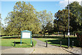
Woodcock Park
Woodcock Park formed part of the grounds of Kenton Grange built as Kenton Lodge in 1803. Open to the public in 1952, the park is a popular recreation area. It is divided into two sections by the Wealdstone Brook, a tributary of the Brent. Normally confined to culverts or concrete ditches, the brook can be seen in a semi natural state for a few hundred metres through the middle of the park.
Image: © Des Blenkinsopp
Taken: 2 Oct 2019
0.12 miles
4
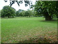
In Woodcock Park
Woodcock Park was once part of the grounds of Kenton Grange, which was built as Kenton Lodge at the start of the 19th century with a small garden behind the house. The land was sold in the 1950s to Middlesex County Council who turned Kenton Grange into an old people's home, and the remaining land into a public park. Much of the park is mown grass except alongside the Wealdstone Brook which runs through the centre of the park.
This is close to the south side of the Wealdstone Brook. For more information and a fuller history of Woodcock Park see http://www.londongardensonline.org.uk/gardens-online-record.asp?ID=BRE042
Image: © Marathon
Taken: 5 Aug 2015
0.12 miles
5
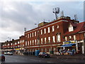
Telephone Exchange, Kenton
In Kenton Park Parade, Kenton Road
Image: © David Hawgood
Taken: 1 Jan 2006
0.12 miles
6
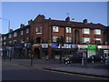
Kenton: Wordsworth telephone exchange
On Kenton Road, looking west. This building probably dates from the 1930s. Modern telephone switchgear is much more compact and does not require such grandiose buildings.
Image: © Dr Neil Clifton
Taken: 1 Apr 2010
0.13 miles
7
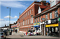
Kenton Kenton Park Parade
Looking east we see this extensive shopping parade on Kenton Road, which is popular as the road is wide enough to allow kerbside car parking. The large building in the centre is the Wordsworth telephone exchange.
Image: © Dr Neil Clifton
Taken: 1 Apr 2010
0.13 miles
8
Kenton Road at junction with Woodcock Hill
Image: © David Howard
Taken: 15 Oct 2009
0.14 miles
9
Woodcock Park, looking north west from Shaftesbury Avenue
Image: © Robert Eva
Taken: 22 Jan 2018
0.14 miles
10
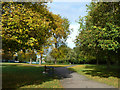
Path, Woodcock Park
A Brent Council park.
Image: © Robin Webster
Taken: 13 Oct 2012
0.14 miles