IMAGES TAKEN NEAR TO
Nightingale Avenue, HARROW, HA1 3GX
Introduction
This page details the photographs taken nearby to Nightingale Avenue, HA1 3GX by members of the Geograph project.
The Geograph project started in 2005 with the aim of publishing, organising and preserving representative images for every square kilometre of Great Britain, Ireland and the Isle of Man.

There are currently over 7.5m images from over14,400 individuals and you can help contribute to the project by visiting https://www.geograph.org.uk
Image Map
Images are licensed for reuse under creativecommons.org/licenses/by-sa/2.0
Notes
- Clicking on the map will re-center to the selected point.
- The higher the marker number, the further away the image location is from the centre of the postcode.
Image Listing (69 Images Found)
Images are licensed for reuse under creativecommons.org/licenses/by-sa/2.0
Image
Details
Distance
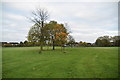
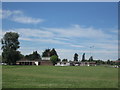
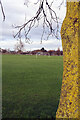
2
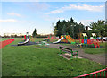
Playground in Northwick Park
Northwick Park together with a golf course and Harrow school sports field makes up a sizable patch of unbuiltover land amidst the North London suburbs.
Image: © Des Blenkinsopp
Taken: 4 Nov 2014
0.09 miles
3
Staff Accommodation, Northwick Park Hospital, 1995
These terraced houses were used by staff working at Northwick Park Hospital. They have since been demolished.
Image: © Mark Anderson
Taken: Unknown
0.09 miles
4
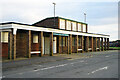
Northwick Park Sports Pavilion
Northwick Park is mainly used for sports pitches and this uninspiring 1950s building provides the central facilities.
Image: © Stephen McKay
Taken: 20 Jan 2023
0.10 miles

7
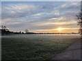
Northwick Park Sunrise
Northwick Park at Sunrise
Image: © Henry Cooke
Taken: 23 Nov 2020
0.14 miles
8
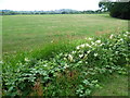
Northwick Park looking towards Harrow-on-the-Hill
What is now Northwick Park was the fields of Sheepcote Farm until the 20th century. The park is named after the Lord of the Manor of Harrow Lord Northwick, the largest landowner in the district in the early 19th century. He lived at Northwick Park, a mansion at Blockley in Worcestershire. Lord Northwick enclosed the commons in the Harrow area with great enthusiasm. This added to the suffering of the agricultural labourers of the area who faced a multitude of other problems. Lord Northwick was probably the most hated man in the area and it is strange that a park which is now of benefit to all commemorates somebody who tried to deny local people access to this land.
Sheepcote Farm was the home of Thomas Grimwade, farmer and inventor of desiccated milk, which was shipped out to Florence Nightingale in the Crimean War.
In 1905, the Harrow School Land Trust obtained most of Sheepcote Farm to prevent it being developed. In 1936, Middlesex County Council and Wembley Urban District Council purchased the Northwick Park Estate as additional open space for the people of Wembley.
This photograph looks across a ditch containing meadowsweet to Harrow-on-the-Hill and its spire on the skyline in the centre.
Image: © Marathon
Taken: 15 Jul 2015
0.15 miles
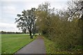
10
Northwick Park
In 1936 Middlesex County Council acquired farmland to the south of Kenton, that had not already been built on by private developers, for the establishment of a park. It was named Northwick Park, which was already used for the adjacent Metropolitan Line station, after the Gloucestershire seat of the former landowners, the Churchill-Rushout family. In the 1960s a significant portion of the park's area was used to build Northwick Park hospital; most of the remaining land is devoted to playing fields.
Image: © Stephen McKay
Taken: 20 Jan 2023
0.16 miles