IMAGES TAKEN NEAR TO
St. James Gardens, WEMBLEY, HA0 4LH
Introduction
This page details the photographs taken nearby to St. James Gardens, HA0 4LH by members of the Geograph project.
The Geograph project started in 2005 with the aim of publishing, organising and preserving representative images for every square kilometre of Great Britain, Ireland and the Isle of Man.

There are currently over 7.5m images from over14,400 individuals and you can help contribute to the project by visiting https://www.geograph.org.uk
Image Map
Images are licensed for reuse under creativecommons.org/licenses/by-sa/2.0
Notes
- Clicking on the map will re-center to the selected point.
- The higher the marker number, the further away the image location is from the centre of the postcode.
Image Listing (113 Images Found)
Images are licensed for reuse under creativecommons.org/licenses/by-sa/2.0
Image
Details
Distance
1
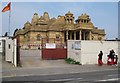
Alperton: Shree Sanatan Hindu Mandir
This Hindu Mandir or temple is under construction on the west side of Ealing Road. The temple is being constructed of carved stonework imported from India and no metal has been used at all. Progress since Danny's Image can be seen. The temple was the site of controversy some time ago when it was alleged that stonemasons recruited in India to work on the site in Alperton were paid very low wages. The Independent's report on this is here http://www.independent.co.uk/news/uk/home-news/craftsmen-given-30p-an-hour-get-pound100000-back-pay-626725.html
Image: © Nigel Cox
Taken: 5 May 2008
0.05 miles
2
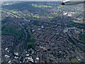
Wembley from the air
The Paddington branch of the Grand Union Canal is visible on the left, Wembley Central railway station is on the right.
Image: © Thomas Nugent
Taken: 19 May 2014
0.08 miles
4
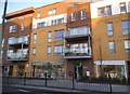
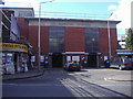
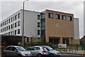
New block of shops on Ealing Road, Alperton
Image: © David Howard
Taken: 11 Feb 2014
0.12 miles
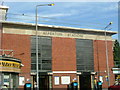
5
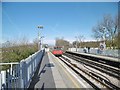
Alperton, underground train
Leaving Alperton, heading for Rayners Lane on the Piccadilly Line.
Image: © Mike Faherty
Taken: 2 Apr 2016
0.12 miles
6
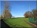
Path up One Tree Hill
A photo that shows that One Tree Hill is now a misnomer. Since its original naming, when it was a hill with a single tree, the park has been landscaped with numerous trees and shrubs.
Image: © Peter S
Taken: 6 Dec 2014
0.12 miles
7
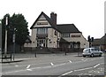
Alperton: The Chequers public house
There has been a licensed premises known as The Chequers on this site, at the junction of Ealing Road and Stanley Avenue, since at least 1751. However it would appear that the pub's days are numbered because Brent Council have, subject to several conditions being met, granted planning permission for the demolition of the pub and the erection of a new building comprising 32 self-contained flats and 2 retail units.
There is a photograph of the pub here http://www.images-of-london.co.uk/jss/product.php?xProd=3013 dating from around 1910 showing a chequerboard pattern in the main gable end, which has since disappeared, but the Art Nouveau tablet above it, with the words "The Chequers Inn", is still present.
Image: © Nigel Cox
Taken: 5 May 2008
0.13 miles
9
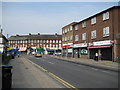
Alperton: Mount Pleasant
Viewed looking towards the junction of Mount Pleasant with the A4089 Ealing Road, the most remarkable thing here is the illustration of the changing demographics. The middle shop on the right is a shop selling Polish goods. The text on the fascia board reads 'Polski sklep' and 'Dobre bo polskie', which, using an on-line translator gives 'Polish store' and 'Good because Polish'.
Image: © Nigel Cox
Taken: 5 May 2008
0.13 miles