IMAGES TAKEN NEAR TO
Stanley Avenue, WEMBLEY, HA0 4LB
Introduction
This page details the photographs taken nearby to Stanley Avenue, HA0 4LB by members of the Geograph project.
The Geograph project started in 2005 with the aim of publishing, organising and preserving representative images for every square kilometre of Great Britain, Ireland and the Isle of Man.

There are currently over 7.5m images from over14,400 individuals and you can help contribute to the project by visiting https://www.geograph.org.uk
Image Map
Images are licensed for reuse under creativecommons.org/licenses/by-sa/2.0
Notes
- Clicking on the map will re-center to the selected point.
- The higher the marker number, the further away the image location is from the centre of the postcode.
Image Listing (46 Images Found)
Images are licensed for reuse under creativecommons.org/licenses/by-sa/2.0
Image
Details
Distance
1
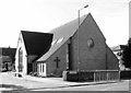
St James Church Centre, Stanley Avenue, Alperton, HA0 4JB
Image: © John Salmon
Taken: 7 Mar 2008
0.01 miles
2
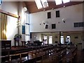
St James Church Centre, Stanley Avenue, Alperton, HA0 4JB - Interior
Image: © John Salmon
Taken: 7 Mar 2008
0.01 miles
3
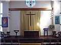
St James Church Centre, Stanley Avenue, Alperton, HA0 4JB - East end
Image: © John Salmon
Taken: 7 Mar 2008
0.01 miles
4
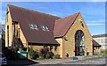
St James Church Centre, Stanley Avenue, Alperton, HA0 4JB
Image: © John Salmon
Taken: 7 Mar 2008
0.02 miles
5
Alperton Community School Upper School
This building housed the grammar school, Wembley County School, which in 1967 was amalgamated with other schools in the area to form the comprehensive school called Alperton High School.
Image: © Rod Allday
Taken: 16 Oct 2015
0.05 miles
7
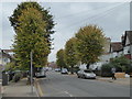
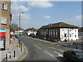
Mount Pleasant, Alperton
Looking towards Woodstock Road. 2 generations of housing here, 1930s style on the right, late 19th century on the left.
Image: © Danny P Robinson
Taken: 6 May 2007
0.13 miles
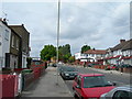
8
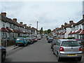
Belmont Avenue, Alperton
1930s terraced housing is very common in the area. This type of housing can be seen all over West London.
Image: © Danny P Robinson
Taken: 6 May 2007
0.15 miles
10
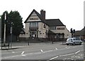
Alperton: The Chequers public house
There has been a licensed premises known as The Chequers on this site, at the junction of Ealing Road and Stanley Avenue, since at least 1751. However it would appear that the pub's days are numbered because Brent Council have, subject to several conditions being met, granted planning permission for the demolition of the pub and the erection of a new building comprising 32 self-contained flats and 2 retail units.
There is a photograph of the pub here http://www.images-of-london.co.uk/jss/product.php?xProd=3013 dating from around 1910 showing a chequerboard pattern in the main gable end, which has since disappeared, but the Art Nouveau tablet above it, with the words "The Chequers Inn", is still present.
Image: © Nigel Cox
Taken: 5 May 2008
0.17 miles