IMAGES TAKEN NEAR TO
Douglas Avenue, WEMBLEY, HA0 4DT
Introduction
This page details the photographs taken nearby to Douglas Avenue, HA0 4DT by members of the Geograph project.
The Geograph project started in 2005 with the aim of publishing, organising and preserving representative images for every square kilometre of Great Britain, Ireland and the Isle of Man.

There are currently over 7.5m images from over14,400 individuals and you can help contribute to the project by visiting https://www.geograph.org.uk
Image Map
Images are licensed for reuse under creativecommons.org/licenses/by-sa/2.0
Notes
- Clicking on the map will re-center to the selected point.
- The higher the marker number, the further away the image location is from the centre of the postcode.
Image Listing (31 Images Found)
Images are licensed for reuse under creativecommons.org/licenses/by-sa/2.0
Image
Details
Distance
1
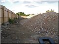
Demolished building on Ealing Road, Alperton
The metal object at the front is part of the lock on the metal gates.
Image: © David Howard
Taken: 2 Aug 2018
0.09 miles
2
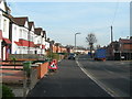
Lyon Park Avenue, Wembley
Near junction with The Close.
Image: © Danny P Robinson
Taken: 4 Feb 2007
0.10 miles
3
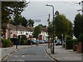
Lyon Park Avenue, Wembley
The housing here dates from the 1930s and is typical of the area.
Image: © Stephen McKay
Taken: 4 Oct 2019
0.11 miles
4
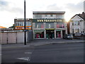
Venisons on Ealing Road, Alperton
Selling Indian Saris there are at least three Venisons in this stretch of shops.
Image: © David Howard
Taken: 2 Aug 2018
0.11 miles
5
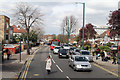
Ealing Road between Alperton and Wembley
The A4089 seen from the top deck of an 83 bus. On the extreme left of the photo is the premises of the Brent Indian Centre. On the right the high rise developments at Wembley Central Station stand tall behind the semi-detached buildings along Ealing Road.
Image: © Martin Addison
Taken: 6 Apr 2012
0.11 miles
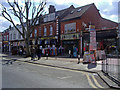
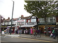
7
Ealing Road, Alperton (3)
A busy Sunday afternoon. Most of the businesses here cater for the area's Asian population.
Image: © Danny P Robinson
Taken: 5 Mar 2006
0.12 miles
8
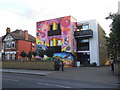
Brent Indian Association, Alperton
It has been painted within the past year.
Image: © David Howard
Taken: 2 Aug 2018
0.13 miles
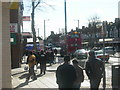
9
Indian shops on Ealing Road, Alperton
You can buy pretty much what you would be buying in India along Ealing Road.
Image: © David Howard
Taken: 17 Apr 2014
0.13 miles
10

Two Bakerloo line trains pass near Wembley Central
The London & Birmingham Railway opened from Euston to Boxmoor in 1837, and on to Birmingham in 1838. In 1846 it became part of the London & North Western Railway. Suburban services were diverted in 1912 to run over the "New Lines", which had just been built: these follow the route used today by Bakerloo line trains. The latter first operated over this section in 1917.
Apart from the West Coast Main Line and the local line operated by London Overground and the Bakerloo line, there is a huge area of sidings extending for two miles, from Harlesden almost to Wembley Central. At their widest these are 350 metres across. Passengers on Bakerloo or London Overground trains at first follow the northern edge of the complex through Stonebridge Park station. Just before Wembley Central, the Bakerloo and Overground pass under the main line to emerge on its southern edge and here the Wembley Brook is crossed. The Wembley Brook is a very short tributary of the River Brent.
This is the view from the long footbridge between Lyon Park Avenue and London Road, just to the south of Wembley Central station, looking in the direction of Wembley Central. The Wembley Brook passes under the tracks just ahead. The Bakerloo train on the left is heading towards Harrow & Wealdstone and the one on the right towards Elephant & Castle. For the view in the other direction see http://www.geograph.org.uk/photo/4216457
Image: © Marathon
Taken: 22 Oct 2014
0.16 miles