IMAGES TAKEN NEAR TO
Lyon Park Avenue, WEMBLEY, HA0 4DR
Introduction
This page details the photographs taken nearby to Lyon Park Avenue, HA0 4DR by members of the Geograph project.
The Geograph project started in 2005 with the aim of publishing, organising and preserving representative images for every square kilometre of Great Britain, Ireland and the Isle of Man.

There are currently over 7.5m images from over14,400 individuals and you can help contribute to the project by visiting https://www.geograph.org.uk
Image Map
Images are licensed for reuse under creativecommons.org/licenses/by-sa/2.0
Notes
- Clicking on the map will re-center to the selected point.
- The higher the marker number, the further away the image location is from the centre of the postcode.
Image Listing (59 Images Found)
Images are licensed for reuse under creativecommons.org/licenses/by-sa/2.0
Image
Details
Distance
1
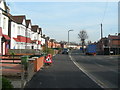
Lyon Park Avenue, Wembley
Near junction with The Close.
Image: © Danny P Robinson
Taken: 4 Feb 2007
0.02 miles
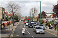
2
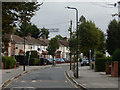
Lyon Park Avenue, Wembley
The housing here dates from the 1930s and is typical of the area.
Image: © Stephen McKay
Taken: 4 Oct 2019
0.03 miles
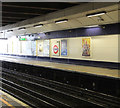
3
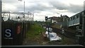
Looking south along the Bakerloo Line / London Overground tracks, from Wembley Central station
Taken from the extreme south end of the platform, where the station just stretches into Image from Image
Image: © Christopher Hilton
Taken: 31 Aug 2016
0.12 miles
4
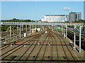
Sidings south of Wembley Central
The lower building in the distance is built on top of Wembley Central station.
Image: © Robin Webster
Taken: 29 Sep 2012
0.13 miles
5
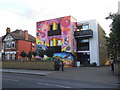
Brent Indian Association, Alperton
It has been painted within the past year.
Image: © David Howard
Taken: 2 Aug 2018
0.13 miles
7
Ealing Road between Alperton and Wembley
The A4089 seen from the top deck of an 83 bus. On the extreme left of the photo is the premises of the Brent Indian Centre. On the right the high rise developments at Wembley Central Station stand tall behind the semi-detached buildings along Ealing Road.
Image: © Martin Addison
Taken: 6 Apr 2012
0.14 miles
8
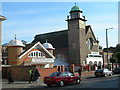
Central Mosque, Wembley
This Mosque is converted from a Church -- it is still even shown as a church on the OS Get-a-Map. The change of use is evidence of the way demographics in the area have altered in the last 30 years.
Image: © Danny P Robinson
Taken: 5 Nov 2006
0.15 miles
9
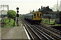
Watford Stopper
An ageing class 501 unit approaches Wembley Central with a local service from Euston to Watford on what are usually referred to as the DC lines. When this was taken in 1985 the 501 slam door stock was being replaced by more recent class 313 units with sliding doors and uncomfortable seats!
The trackside electric live rails warning signs are rusted and fading. The more recent 'passengers must not cross the line' sign doesn't look much better. In the distance the line curves to the left to pass under the main line and the carriage sidings at Stonebridge Park.
Image: © Martin Addison
Taken: Unknown
0.16 miles
10
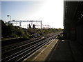
DC lines south from Wembley Central station
Looking towards Euston from the Down DC lines platform. Here, the DC lines (so called because they are electrified using a direct current system) swing away from the West Coast Main Line (whose AC electrification gantries are visible on the left) so they can pass under it near the Down end of Willesden yard.
Image: © Richard Vince
Taken: 8 Nov 2018
0.16 miles