IMAGES TAKEN NEAR TO
The Crescent, WEMBLEY, HA0 3JR
Introduction
This page details the photographs taken nearby to The Crescent, HA0 3JR by members of the Geograph project.
The Geograph project started in 2005 with the aim of publishing, organising and preserving representative images for every square kilometre of Great Britain, Ireland and the Isle of Man.

There are currently over 7.5m images from over14,400 individuals and you can help contribute to the project by visiting https://www.geograph.org.uk
Image Map (Loading...)


Getting Data...Please wait
Leaflet Map data © OpenStreetMap
Images are licensed for reuse under creativecommons.org/licenses/by-sa/2.0
Notes
- Clicking on the map will re-center to the selected point.
- The higher the marker number, the further away the image location is from the centre of the postcode.
Image Listing (33 Images Found)
Images are licensed for reuse under creativecommons.org/licenses/by-sa/2.0
Image
Details
Distance
1
Harrow on The Hill : Sudbury Court Drive
From the roundabout on Watford Road looking along Sudbury Court Drive.
Image: © Lewis Clarke
Taken: 12 Sep 2020
0.05 miles
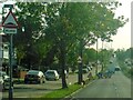
2

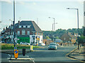
Watford Road, roundabout
This is at the bottom of the A4127 Sudbury Court Drive, and the roads in view are The Crescent and the A404 Watford Road. Many of the houses round here were built with distinctive green rooves.
Image: © Danny P Robinson
Taken: 21 May 2006
0.06 miles
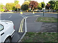
3
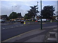
John Lyon Roundabout, Sudbury
From Watford Road looking north
Image: © David Howard
Taken: 2 Nov 2010
0.06 miles
5
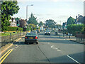
Harrow on The Hill : Watford Road
Looking along Watford Road.
Image: © Lewis Clarke
Taken: 12 Sep 2020
0.10 miles
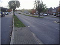
6
Harrow on The Hill : Sudbury Court Drive A4127
Looking along Sudbury Court Drive.
Image: © Lewis Clarke
Taken: 12 Sep 2020
0.11 miles
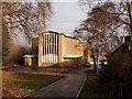
7
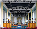
St Cuthbert, Watford Road, Wembley - East end
Image: © John Salmon
Taken: 17 Nov 2004
0.12 miles
8
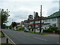
Houses on Watford Road, Kenton
These are larger than the average semi detached houses in the area.
Image: © Danny P Robinson
Taken: 21 May 2006
0.12 miles
10
St Cuthbert's Church, North Wembley
This church was built in 1959. Its predecessor, a wooden mission hut, was desstroyed by a bomb in 1940. See Victoria County History for Middlesex, Harrow Modern Churches at http://www.british-history.ac.uk/report.asp?compid=22473. It is at the western end of Carlton Avenue W, at the southern edge of Northwick Park. See Church of England parish website http://www.stcuths.org/.
Image: © David Hawgood
Taken: 31 Dec 2005
0.14 miles