IMAGES TAKEN NEAR TO
Central Road, WEMBLEY, HA0 2LJ
Introduction
This page details the photographs taken nearby to Central Road, HA0 2LJ by members of the Geograph project.
The Geograph project started in 2005 with the aim of publishing, organising and preserving representative images for every square kilometre of Great Britain, Ireland and the Isle of Man.

There are currently over 7.5m images from over14,400 individuals and you can help contribute to the project by visiting https://www.geograph.org.uk
Image Map
Images are licensed for reuse under creativecommons.org/licenses/by-sa/2.0
Notes
- Clicking on the map will re-center to the selected point.
- The higher the marker number, the further away the image location is from the centre of the postcode.
Image Listing (106 Images Found)
Images are licensed for reuse under creativecommons.org/licenses/by-sa/2.0
Image
Details
Distance
1
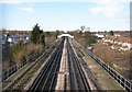
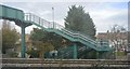
Piccadilly Line in Sudbury (3)
The houses in Sudbury Heights Avenue are to the left while those in District Road are to the right, with the image taken from the footbridge carrying the footpath between them over the railway. Another such footpath footbridge is in the distance. The footpaths actually predate both the railway and the houses as is evidenced by Victorian Ordnance Survey maps which show a network of footpaths radiating from the then hamlet of Sudbury.
Image: © Nigel Cox
Taken: 2 Jan 2010
0.07 miles
2
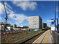
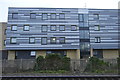
Building Site by the Station
This is Sudbury and Harrow Road Station which has the dubious honour of being the least used station in London.
Not surprising as hardly any trains stop here so that's a kind of Chicken & Egg statistic.
Maybe with new housing going up over the fence there will be some more passengers around.
Image: © Des Blenkinsopp
Taken: 30 Mar 2016
0.08 miles
6
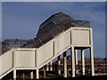
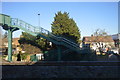
Sudbury Heights Ave - Footbridge
Footbridge from Sudbury Heights Ave to Maybank Open Space
(Piccadilly Line)
Image: © Russell Trebor
Taken: 14 Jan 2007
0.09 miles
7
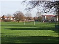
Maybank Open Space
Barham Park Estate In Distance
Image: © Russell Trebor
Taken: 14 Jan 2007
0.09 miles
9
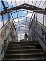
Footbridge Maybank Open Space
Bridge over Piccadilly Line
Image: © Russell Trebor
Taken: 17 Jun 2006
0.09 miles
10
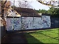
Graffiti Hit Wall - Maybank Open Space
Image: © Russell Trebor
Taken: 14 Jan 2007
0.10 miles