IMAGES TAKEN NEAR TO
Westlinks, Alperton Lane, WEMBLEY, HA0 1ER
Introduction
This page details the photographs taken nearby to Westlinks, Alperton Lane, HA0 1ER by members of the Geograph project.
The Geograph project started in 2005 with the aim of publishing, organising and preserving representative images for every square kilometre of Great Britain, Ireland and the Isle of Man.

There are currently over 7.5m images from over14,400 individuals and you can help contribute to the project by visiting https://www.geograph.org.uk
Image Map
Images are licensed for reuse under creativecommons.org/licenses/by-sa/2.0
Notes
- Clicking on the map will re-center to the selected point.
- The higher the marker number, the further away the image location is from the centre of the postcode.
Image Listing (33 Images Found)
Images are licensed for reuse under creativecommons.org/licenses/by-sa/2.0
Image
Details
Distance
1
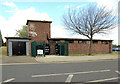
Disused public conveniences, Alperton Lane, Alperton
Image: © MrC
Taken: 21 May 2009
0.03 miles
2
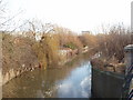
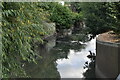
River Brent from Western Avenue
The river is flowing from the Brent reservoir and Alperton, goes under the A40 here, and continues to Greenford, and eventually The Thames. Usually it is very shallow here but after heavy rain there is much more water, and debris can be seen in the branches where there the level has been higher.
Image: © David Hawgood
Taken: 19 Jan 2007
0.11 miles
3
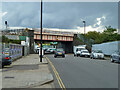
Railway bridge over B456 Alperton Lane
Carrying the Central Line (near) and Network Rail's Acton - Northolt line.
Image: © Robin Webster
Taken: 13 Oct 2012
0.13 miles
5
Vanguard building from Brentham Meadows, Ealing
Image: © Ruth Sharville
Taken: 22 May 2011
0.14 miles
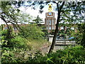
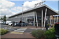
6
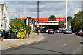
Vanguard Self Storage
On the tower is a remarkable larger than life-size model of an assembly of things of the sort that might be put into storage. This is to catch the eye of users of the A40 just the other side of the site.
Image: © Robin Webster
Taken: 13 Oct 2012
0.15 miles
8
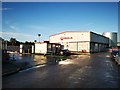
Marsh Lane
Trading estate near the River Brent.
Veolia is a multinational company based in Paris.
https://en.wikipedia.org/wiki/Veolia_Environmental_Services
Image: © James Emmans
Taken: 17 Aug 2019
0.15 miles
10
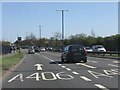
Western Avenue (A40) in the Brent Valley
Lane markings are advance warning for the major junction with the North Circular Road at Hanger Lane.
Image: © Peter Whatley
Taken: 1 Apr 2012
0.16 miles