IMAGES TAKEN NEAR TO
Norwood Lane, PETWORTH, GU28 0QQ
Introduction
This page details the photographs taken nearby to Norwood Lane, GU28 0QQ by members of the Geograph project.
The Geograph project started in 2005 with the aim of publishing, organising and preserving representative images for every square kilometre of Great Britain, Ireland and the Isle of Man.

There are currently over 7.5m images from over14,400 individuals and you can help contribute to the project by visiting https://www.geograph.org.uk
Image Map
Images are licensed for reuse under creativecommons.org/licenses/by-sa/2.0
Notes
- Clicking on the map will re-center to the selected point.
- The higher the marker number, the further away the image location is from the centre of the postcode.
Image Listing (13 Images Found)
Images are licensed for reuse under creativecommons.org/licenses/by-sa/2.0
Image
Details
Distance
1
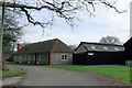
Lavington Stud
Some of the buildings - those nearest the public lane - of this large stud farm.
Image: © Robin Webster
Taken: 13 Feb 2007
0.01 miles
2
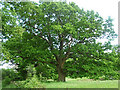
Oak, Upper Norwood
A mighty, venerable oak which must have seen some things.
Just think what it could tell us ... if it had eyes, and the ability to talk, and we had the requisite devices for translating.
Image: © Stephen Richards
Taken: Unknown
0.07 miles

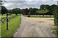
4
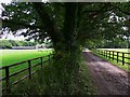
Farm track near Upper Norwood
The buildings to the left are marked on Get-a-map (and also on my old OS Pathfinder) as Old Park. They are part of Lavington Stud Farm now.
Image: © Shazz
Taken: 28 Aug 2010
0.09 miles
5
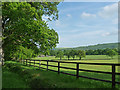
Farmland, Upper Norwood
The other side of the fence is a stud farm.
The South Downs provide the backdrop.
Image: © Stephen Richards
Taken: Unknown
0.12 miles
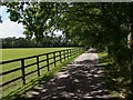
6

Norwood Lane, Upper Norwood (1)
On the left is Brooks's Copse.
Image: © Stephen Richards
Taken: Unknown
0.16 miles
9
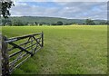
Gateway with a view
An open gate to fields beside the public footpath. The spot provides a view of the wooded flanks of the South Downs ahead.
Image: © Chris Thomas-Atkin
Taken: 19 Aug 2021
0.19 miles
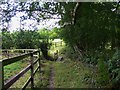
10
Path junction
A path junction near Upperbarn House. The public footpath leading off to the right passes through Brook’s Copse to join Norwood Lane.
Image: © Chris Thomas-Atkin
Taken: 19 Aug 2021
0.19 miles