IMAGES TAKEN NEAR TO
West End Lane, HASLEMERE, GU27 2EN
Introduction
This page details the photographs taken nearby to West End Lane, GU27 2EN by members of the Geograph project.
The Geograph project started in 2005 with the aim of publishing, organising and preserving representative images for every square kilometre of Great Britain, Ireland and the Isle of Man.

There are currently over 7.5m images from over14,400 individuals and you can help contribute to the project by visiting https://www.geograph.org.uk
Image Map
Images are licensed for reuse under creativecommons.org/licenses/by-sa/2.0
Notes
- Clicking on the map will re-center to the selected point.
- The higher the marker number, the further away the image location is from the centre of the postcode.
Image Listing (32 Images Found)
Images are licensed for reuse under creativecommons.org/licenses/by-sa/2.0
Image
Details
Distance
1
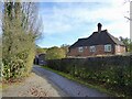
Little Frillinghurst
The house was built in the first decade of the 20th century.
Image: © Simon Carey
Taken: 27 Oct 2024
0.02 miles
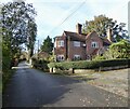
3
House at Frillinghurst
This same house is seen from the other direction at http://www.geograph.org.uk/photo/291779 .
Image: © Shazz
Taken: 4 Apr 2010
0.05 miles
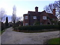
4
Frillinghurst Farm
Marked on older OS maps as Jays Farm and built in the first decade of the 20th century.
Image: © Simon Carey
Taken: 27 Oct 2024
0.05 miles
5
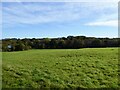
Site of Frillinghurst Wood (1)
Once the south eastern section of Frillinghurst. The wood still existed on a 1948 aerial map but had disappeared by the time of a 1965 OS map. Another former part of the wood was located north of the public bridleway, see Image
Image: © Simon Carey
Taken: 27 Oct 2024
0.06 miles
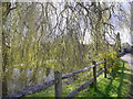
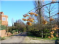
6
The bridleway through Frillinghurst
This is the view east.
Image: © Shazz
Taken: 4 Apr 2010
0.06 miles
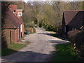
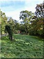
7
Frillinghurst
A collection of farms, houses and stables at the end of a Wealden lane.
Image: © Colin Smith
Taken: 9 Dec 2006
0.07 miles
8
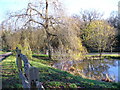
Pond at Frillinghurst
Bare trees are reflected in the pond. Many Wealden farms had ponds to water their animals, but today those remaining are mainly ornamental.
Image: © Colin Smith
Taken: 9 Dec 2006
0.07 miles
9
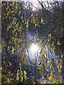
Frillinghurst Reflections
The pond catches the low midwinter sunshine.
Image: © Colin Smith
Taken: 9 Dec 2006
0.07 miles
10
Rough Field
The name of the field according to Chiddingfold's 1842 tithe map which is located to the west of Jubilee Cottages. Beyond amongst the trees is the former pond bay belonging to West End Furnace, see Image and Image
Image: © Simon Carey
Taken: 27 Oct 2024
0.08 miles