IMAGES TAKEN NEAR TO
Charlton Down, TETBURY, GL8 8TZ
Introduction
This page details the photographs taken nearby to Charlton Down, GL8 8TZ by members of the Geograph project.
The Geograph project started in 2005 with the aim of publishing, organising and preserving representative images for every square kilometre of Great Britain, Ireland and the Isle of Man.

There are currently over 7.5m images from over14,400 individuals and you can help contribute to the project by visiting https://www.geograph.org.uk
Image Map
Images are licensed for reuse under creativecommons.org/licenses/by-sa/2.0
Notes
- Clicking on the map will re-center to the selected point.
- The higher the marker number, the further away the image location is from the centre of the postcode.
Image Listing (16 Images Found)
Images are licensed for reuse under creativecommons.org/licenses/by-sa/2.0
Image
Details
Distance
1
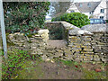
Stone Stile, Hookhouse Lane
In the areas known as Charlton Down, this is a modern interpretation of a stone stile on the Gloucestershire footpath NTU24. Looking East from the road, the view looking West is Image
Image: © Mr Red
Taken: 22 Dec 2021
0.03 miles
2
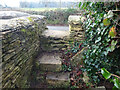
Stone Stile, Hookhouse Lane
In the areas known as Charlton Down, this is a modern interpretation of a stone stile on the Gloucestershire footpath NTU24. Looking West to the road, the view looking East is Image
Image: © Mr Red
Taken: 22 Dec 2021
0.03 miles
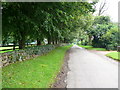
3
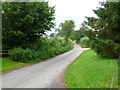
Hookshouse Lane Charlton Down
This small country lane runs past Charlton Down which used to be called Elmstree Farm before the Second World war. The Macmillan Way runs along the lane at this point.
Image: © Nigel Mykura
Taken: 8 Jul 2012
0.05 miles
4
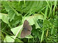
Ringlet butterfly
Alongside Hookshouse Lane. An attractive butterfly, despite its lack of bright colours.
Image: © Alan Murray-Rust
Taken: 27 Jun 2017
0.07 miles
5
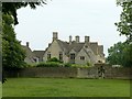
Charlton Down House
A large country house, dated 1848.
Image: © Alan Murray-Rust
Taken: 27 Jun 2017
0.11 miles
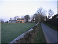
6
Hooks House Lane
Looking south along this small country lane with the dry stone wall of Charlton Down on the left. The name Charlton originates from the old English Ceorl (pronounced churl) hence Charlton is where the ceorls ( a freeman of the lowest rank in Anglo-Saxon England) lived. The adjective churlish derives from this.
Image: © Nigel Mykura
Taken: 8 Jul 2012
0.14 miles
7
Approaching Hookshouse
A view looking north along Hookshouse Lane towards a converted barn at Hookshouse.
Image: © Phil Williams
Taken: 23 Jan 2007
0.17 miles
8
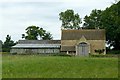
Barn at Hookshouse
Described as converted in 2007 http://www.geograph.org.uk/photo/319259 , it certainly doesn't appear to be permanently occupied.
Image: © Alan Murray-Rust
Taken: 27 Jun 2017
0.17 miles
9
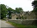
Nesley Down, Hookshouse
A substantial single house created out of a range of estate cottages.
Image: © Alan Murray-Rust
Taken: 27 Jun 2017
0.20 miles
10
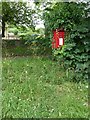
Hookshouse postbox ref GL8 193
Standard EIIR lamp box, in danger of being swamped by vegetation.
Image: © Alan Murray-Rust
Taken: 27 Jun 2017
0.20 miles