IMAGES TAKEN NEAR TO
Tetbury Road, CIRENCESTER, GL7 6NZ
Introduction
This page details the photographs taken nearby to Tetbury Road, GL7 6NZ by members of the Geograph project.
The Geograph project started in 2005 with the aim of publishing, organising and preserving representative images for every square kilometre of Great Britain, Ireland and the Isle of Man.

There are currently over 7.5m images from over14,400 individuals and you can help contribute to the project by visiting https://www.geograph.org.uk
Image Map
Images are licensed for reuse under creativecommons.org/licenses/by-sa/2.0
Notes
- Clicking on the map will re-center to the selected point.
- The higher the marker number, the further away the image location is from the centre of the postcode.
Image Listing (62 Images Found)
Images are licensed for reuse under creativecommons.org/licenses/by-sa/2.0
Image
Details
Distance
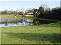
1
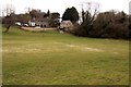
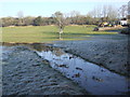
Thames Head Cottages overlook the dry field
The infant River Thames can flow through this field in wet weather.
Image: © Steve Daniels
Taken: 14 Apr 2013
0.01 miles
2
Course of Thames & Severn Canal at Thames Head
To the east of Thames Head Bridge the canal bed has been turned into a driveway. This leads to a private house built on the site of Thames Head pumping station, constructed in an attempt to maintain the water levels in this notoriously leaky length of the canal.
Image: © David Stowell
Taken: 12 Mar 2009
0.04 miles
3
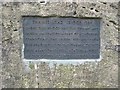
Plaque on Thames Head Bridge
The plaque recording the origin of Image over the Thames and Severn Canal
Image: © David Stowell
Taken: 12 Mar 2009
0.04 miles
4
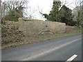
Thames Head Bridge
The Fosse Way crossed the Thames and Severn Canal at this point. The road was realigned in 1962 to bypass the bridge however the bridge still remains providing access to a canalside house. A Image commemorates its origin.
Image: © David Stowell
Taken: 12 Mar 2009
0.04 miles
5
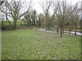
Flooded field on the Thames Path near the source of the River Thames near the A433 Cirencester to Tetbury road
The dwellings are next to the redundant Thames and Severn canal where the dry canal goes under the A433
Image: © Paul Best
Taken: 14 Jan 2014
0.04 miles
6
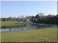
View to Thames Head Cottages
A pool on the infant River Thames forms upstream of the Foss Way in wet periods.
Two months later it has disappeared. Image
Image: © John M
Taken: 19 Feb 2013
0.04 miles
7
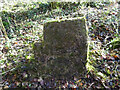
Boundary stone, Kemble/Coates
A curious stepped stone, in a stonewalled alcove down the steep embankment of the A433 Fosse Way near Thameshead. It marks the boundary between Coates to the NW and Kemble to the SE.
Milestone Society National ID: GL_COAKEM01pb
Image: © Mr Red
Taken: 1 Dec 2020
0.04 miles
8
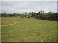
View across the Thames Valley
Looking from the Wysis Way/Thames Head path across to Thames Head and the line of the Thames & Severn Canal to the left. The land in the foreground is downstream of the official source of the Thames however water only appears here after periods of very wet weather. The hedge to the right marks the line of the Fosse Way.
Image: © David Stowell
Taken: 12 Mar 2009
0.05 miles
9
River Thames pool outlet upstream of Fosse Way
The outlet from the pool flows under the Fosse Way embankment in a small culvert.
Image: © John M
Taken: 19 Feb 2013
0.06 miles
10
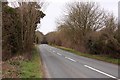
The Fosse Way to Cirencester
The Fosse Way was a Roman Road that linked Exeter to Lincoln.
Image: © Steve Daniels
Taken: 14 Apr 2013
0.06 miles