IMAGES TAKEN NEAR TO
Station Road, CHELTENHAM, GL54 2EN
Introduction
This page details the photographs taken nearby to Station Road, GL54 2EN by members of the Geograph project.
The Geograph project started in 2005 with the aim of publishing, organising and preserving representative images for every square kilometre of Great Britain, Ireland and the Isle of Man.

There are currently over 7.5m images from over14,400 individuals and you can help contribute to the project by visiting https://www.geograph.org.uk
Image Map
Images are licensed for reuse under creativecommons.org/licenses/by-sa/2.0
Notes
- Clicking on the map will re-center to the selected point.
- The higher the marker number, the further away the image location is from the centre of the postcode.
Image Listing (421 Images Found)
Images are licensed for reuse under creativecommons.org/licenses/by-sa/2.0
Image
Details
Distance
1
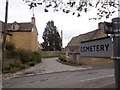
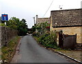
Cemetery Lane
The lane starts at Station Road.
Image: © Michael Dibb
Taken: 2 Apr 2011
0.01 miles
2
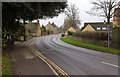
Station Road
The main route into and out of Bourton-on-the-Water.
Image: © David P Howard
Taken: 20 Nov 2014
0.02 miles
3
Bella Dorma in Bourton-on-the-Water
Bella Dorma bed & breakfast guest house viewed across Station Road.
Image: © Jaggery
Taken: 5 Aug 2014
0.02 miles
4
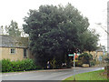
Holm Oak at the bend of Station Road, Bourton-on-the-Water
The scientific name of Holm Oak is Quercus ilex. It is often seen associated with late 18th and early 19th-century houses. The fingerpost indicates the northeasterly route of the Oxfordshire Way recreational path.
Image: © Robin Stott
Taken: 20 Nov 2014
0.02 miles
5
NW end of Cemetery Lane, Bourton-on-the-Water
Viewed from the corner of Greystones Lane, near Station Road.
Image: © Jaggery
Taken: 5 Aug 2014
0.03 miles
6
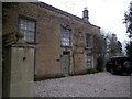
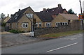
Camp House
The front of this house, listed Grade II, is delightful. The house is late 18th century with some older work in the rear wing.
Image: © Michael Dibb
Taken: 2 Apr 2011
0.03 miles
7
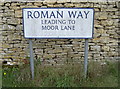
Roman Way
Parts of the area surrounding Bourton-on-the-Water have yielded some archaeology from the Roman period. It's not surprising as the Fosse Way runs close to the west. However, the Saxons appear to have had a light impact here with only a few remains found so far, so perhaps their name is not so important.
Image: © Neil Owen
Taken: 6 Aug 2014
0.03 miles
8
Station Road
Looking up the road and thence on to the site of the old railway station. This end of the road features some post-war housing but the station itself closed in 1964. See Image] for the street sign.
Image: © Neil Owen
Taken: 6 Aug 2014
0.03 miles
9
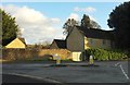
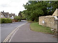
Road junction, Bourton-On-The-Water
On the right, Station Road swings around a bend; to the left, Roman Way heads off carrying the Oxfordshire Way, which then follows Moor Lane. Ahead is the late C18 Camp House https://www.historicengland.org.uk/listing/the-list/list-entry/1088713 .
Image: © Derek Harper
Taken: 28 Jan 2017
0.03 miles
10
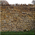
Modern dry stone wall, Roman Way, Bourton-on-the-Water
Estimated to be six feet (1·8m) high, at the junction with Station Road.
Image: © Robin Stott
Taken: 20 Nov 2014
0.03 miles