
IMAGES TAKEN NEAR TO
Dudbridge Road, STROUD, GL5 3HF
Introduction
This page details the photographs taken nearby to Dudbridge Road, GL5 3HF by members of the Geograph project.
The Geograph project started in 2005 with the aim of publishing, organising and preserving representative images for every square kilometre of Great Britain, Ireland and the Isle of Man.

There are currently over 7.5m images from over14,400 individuals and you can help contribute to the project by visiting https://www.geograph.org.uk
Image Map
Images are licensed for reuse under creativecommons.org/licenses/by-sa/2.0
Notes
- Clicking on the map will re-center to the selected point.
- The higher the marker number, the further away the image location is from the centre of the postcode.
Image Listing (68 Images Found)
Images are licensed for reuse under creativecommons.org/licenses/by-sa/2.0
Image
Details
Distance
1
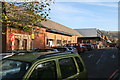
Sainsbury's, Dudbridge
This large supermarket incorporates stone door frames (centre left) from a former clothiers house in this locality.
Image: © Chris Allen
Taken: 23 Nov 2013
0.08 miles
2
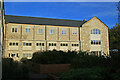
Dudbridge Mills, Stroud
Former textile mills that were later used by Redlers to manufacture conveyors. The older, stone built part visible here has been converted to housing while behind is a section that I think is in multiple occupancy.
Image: © Chris Allen
Taken: 23 Nov 2013
0.08 miles
3
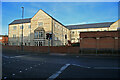
Dudbridge Mills, Stroud
Former textile mills that were later used by Redlers to manufacture conveyors. The part visible here has been converted to housing while behind is a section that I think is in multiple occupancy.
Image: © Chris Allen
Taken: 23 Nov 2013
0.09 miles
4
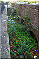
Watercourse, Dudbridge
This is between the main road and a Sainsbury's at Dudbridge and is likely to represent part of a former watercourse supplying a water powered mill. There is absolutely no interpretation associated with this feature.
I would appreciate any further information or corrections on this image.
Image: © Chris Allen
Taken: 23 Nov 2013
0.09 miles
5
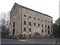
Kimmins Mill, Dudbridge
A former flour mill.
Image: © Chris Andrews
Taken: 16 Apr 2019
0.09 miles
6
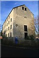
Kimmins Mill, Dudbridge
A five storey stone flour mill with a date stone of 1849. It had a water wheel at the opposite end and at one time had steam power but the chimney has now gone. It was once connected by viaduct and narrow gauge railway to the Stonehouse & Nailsworth railway but the connection has gone. It is now in a Sainsbury's car park.
Image: © Chris Allen
Taken: 23 Nov 2013
0.09 miles
7
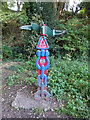
National Cycle Network signpost, Dudbridge Junction
On the old Midland Rail line where the original line diverted to Stroud or to Nailsworth. Route 45. There are earlier images despite the differences in OSGR. see https://www.geograph.org.uk/photo/1409723 & https://www.geograph.org.uk/photo/6230170
Millennium Time Trail ID: MP691 see http://umap.openstreetmap.fr/en/map/sustrans-mileposts_71773#15/51.7372/-2.2371
Image: © Mr Red
Taken: 17 Sep 2020
0.09 miles
8

River Frome at Dudbridge, Stroud
Flowing between the offices of Redlers and the mill now converted to apartments.
Image: © Roger May
Taken: 26 Jul 2012
0.10 miles
9
Approaching roundabout at Sainsbury's store Dudbridge
Image: © John Firth
Taken: 4 Sep 2017
0.10 miles
10

Midland Railway junction
A National Cycle trail 45 marker at the junction of the disused Midland Railway from Nailsworth to Stonehouse and the branch to Stroud.
Image: © don cload
Taken: 6 Aug 2019
0.10 miles