IMAGES TAKEN NEAR TO
Ermin Drive, GLOUCESTER, GL4 8BP
Introduction
This page details the photographs taken nearby to Ermin Drive, GL4 8BP by members of the Geograph project.
The Geograph project started in 2005 with the aim of publishing, organising and preserving representative images for every square kilometre of Great Britain, Ireland and the Isle of Man.

There are currently over 7.5m images from over14,400 individuals and you can help contribute to the project by visiting https://www.geograph.org.uk
Image Map
Images are licensed for reuse under creativecommons.org/licenses/by-sa/2.0
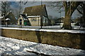
Notes
- Clicking on the map will re-center to the selected point.
- The higher the marker number, the further away the image location is from the centre of the postcode.
Image Listing (35 Images Found)
Images are licensed for reuse under creativecommons.org/licenses/by-sa/2.0
Image
Details
Distance
1
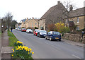
Old London Road, Birdlip
This was the Roman Ermin Way, the Gloucester to London turnpike and the A417; now thankfully bypassed.
Image: © Jonathan Billinger
Taken: 6 Dec 2013
0.07 miles
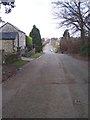
2
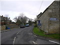
Ermin Way at Birdlip
Ermin Way is a Roman Road between Silchester and Gloucester, here it passes through Birdlip, high on the Cotswolds. The road in Birdlip used to be part of the A417 but it is now bypassed.
Image: © Philip Halling
Taken: 7 Feb 2009
0.07 miles
3
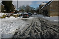
Birdlip Primary School
The parents of Birdlip must be quite glad that the A417 doesn't come roaring past here anymore!
Image: © Jonathan Billinger
Taken: 9 Jan 2007
0.09 miles
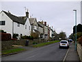
4
Birdlip Primary School
Birdlip Primary School used to be beside the busy A417, nowadays the village has been bypassed and the village is on a quiet no through road.
Image: © Philip Halling
Taken: 7 Feb 2009
0.10 miles
5
High Street, Birdlip
This was the Roman Ermin Way, the Gloucester to London turnpike and the A417; now thankfully bypassed.
Image: © Jonathan Billinger
Taken: 6 Dec 2013
0.10 miles
6
Ermin Way, Birdlip
The Roman Road from Cirencester to Gloucester on the last leg on the top of the Cotswold escarpment before the steep drop down the scarp slope. Looking WNW towards Gloucester.
Image: © Bob Embleton
Taken: 1 Mar 2006
0.13 miles
7
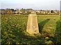
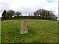
Trig Point 1380 Birdlip
Triangulation Pillar at Birdlip
Image: © Damon Knight
Taken: 31 Jan 2006
0.14 miles
8
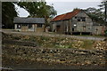
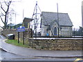
Old shed in Birdlip
Two old sheds in the centre of the village of Birdlip. This site has since been redeveloped with housing Image]
Image: © Philip Halling
Taken: 14 Oct 2007
0.15 miles
9
Birdlip Hill
Trig quickly bagged then over damaged wooden fence to walk on grass roof of covered reservoir with no problem.
Name: Birdlip Hill
Hill number: 5380
Height: 303m / 994ft
Area: 39: Central and Eastern England
Class: Hu
Grid ref: SO 92503 14124
Summit feature: covered reservoir (accessible) West of trig point
Drop: 120m
Col: 183m SP009203
Image: © Rude Health
Taken: 5 Mar 2012
0.15 miles