IMAGES TAKEN NEAR TO
Green Bank, GLOUCESTER, GL3 4NB
Introduction
This page details the photographs taken nearby to Green Bank, GL3 4NB by members of the Geograph project.
The Geograph project started in 2005 with the aim of publishing, organising and preserving representative images for every square kilometre of Great Britain, Ireland and the Isle of Man.

There are currently over 7.5m images from over14,400 individuals and you can help contribute to the project by visiting https://www.geograph.org.uk
Image Map (Loading...)


Getting Data...Please wait
Leaflet Map data © OpenStreetMap
Images are licensed for reuse under creativecommons.org/licenses/by-sa/2.0
Notes
- Clicking on the map will re-center to the selected point.
- The higher the marker number, the further away the image location is from the centre of the postcode.
Image Listing (5 Images Found)
Images are licensed for reuse under creativecommons.org/licenses/by-sa/2.0
Image
Details
Distance
1
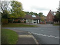
Brockworth Surgery
On Abbotswood Road, http://www.brockworthsurgery.nhs.uk/
Image: © Mike Faherty
Taken: 16 Oct 2009
0.16 miles
2
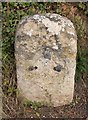
Old Milestone by Ermine Street, Brockworth parish
Stone post (plate lost) by the UC road (Ermin Way), in parish of BROCKWORTH (TEWKESBURY District), Ermin Street; 70m East of junction with Vicarage Lane in front No.89, on the verge, on North side of road. Northgate plate, erected by the Northgate turnpike trust in the 18th century.
Inscription once read:-
(Gloucester)
(4)
Gloucestershire County Council HER.
HER: 35155 https://www.heritagegateway.org.uk/Gateway/Results_Single.aspx?uid=35155&resourceID=108
Milestone Society National ID: GL_GLBL04.
Image: © M Faherty
Taken: 16 Oct 2009
0.22 miles
3
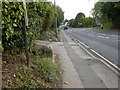
Brockworth, milestone
Milestone on Ermin Street on the old turnpike road to Birdlip; the iron plate is missing, but according to old OS maps, stated 4 miles to Gloucester.
Image: © Mike Faherty
Taken: 16 Oct 2009
0.22 miles
4
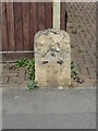
Old Milestone by UC road (Ermin Way), Ermin Street; 70m East of junction with Vicarage Lane in front No 89
The Milestone is located on the verge on the North of the road. Parish of Brockworth (Tewkesbury District). Stone post (plate lost), Northgate plate design, erected by the Northgate turnpike trust in the 18th Century, Chips on edges, pitting. An earlier photograph can be found here: https://www.geograph.org.uk/photo/6050209Â
Inscription reads:- (Gloucester 4)
Milestone Society National ID: GL_GLBL04
Image: © Roadside Relics
Taken: 13 Sep 2023
0.22 miles
5
Brockworth, Roman road
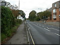
Ermin Way, from Gloucester to Cirencester. http://www.highways.gov.uk/roads/projects/6038.aspx
Image: © Mike Faherty
Taken: 16 Oct 2009
0.23 miles