IMAGES TAKEN NEAR TO
Juniper Way, GLOUCESTER, GL3 4FQ
Introduction
This page details the photographs taken nearby to Juniper Way, GL3 4FQ by members of the Geograph project.
The Geograph project started in 2005 with the aim of publishing, organising and preserving representative images for every square kilometre of Great Britain, Ireland and the Isle of Man.

There are currently over 7.5m images from over14,400 individuals and you can help contribute to the project by visiting https://www.geograph.org.uk
Image Map
Images are licensed for reuse under creativecommons.org/licenses/by-sa/2.0
Notes
- Clicking on the map will re-center to the selected point.
- The higher the marker number, the further away the image location is from the centre of the postcode.
Image Listing (23 Images Found)
Images are licensed for reuse under creativecommons.org/licenses/by-sa/2.0
Image
Details
Distance
1
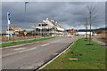
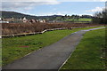
Housing development, Coopers Edge
The former Brockworth Airfield is being redeveloped with housing with the result that Gloucester is spreading out to the east of the M5 motorway.
Image: © Philip Halling
Taken: 26 Feb 2011
0.06 miles
2
Former Brockworth Airfield
View across the western edge of the former Brockworth Airfield which is being redeveloped into a housing estate along with business and retail units. David Wilson Homes is one of the building firms working here. Churchdown or Chosen Hill can be seen in the distance.
Image: © Philip Halling
Taken: 26 Feb 2011
0.11 miles
3
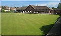
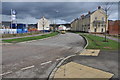
Pineholt Bowls Club, Hucclecote
On the outskirts of Gloucester.
Image: © andrew auger
Taken: 28 Aug 2017
0.15 miles
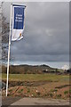
4
View to Nut Hill
View to Nut hill from the western edge of what was once Brockworth Airfield which is currently undergoing redevelopment.
Image: © Philip Halling
Taken: 26 Feb 2011
0.17 miles
5
Development at Coopers Edge
The former Brockworth Airfield is undergoing redevelopment with business and retail premises along with residential housing.
Image: © Philip Halling
Taken: 26 Feb 2011
0.18 miles
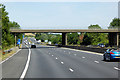
6
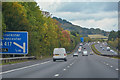
Gloucester : The M5 Motorway Southbound
Heading south on the M5 near Gloucester on a drizzly grey day.
Image: © Lewis Clarke
Taken: 6 Feb 2012
0.18 miles
7
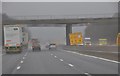
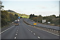
Tewkesbury Borough : M5 Motorway
The M5 Motorway between Junction 12 and Junction 11A (Brockworth Interchange).
Image: © Lewis Clarke
Taken: 30 Sep 2018
0.19 miles
8
Tewkesbury District : The M5 Motorway
The M5 Motorway heading north in Gloucestershire.
Image: © Lewis Clarke
Taken: 29 Oct 2013
0.19 miles
9
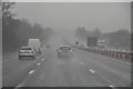
Gloucester : The M5 Motorway Northbound
A wet a dreary day near Gloucester as we travel along the M5 motorway.
Image: © Lewis Clarke
Taken: 6 Feb 2012
0.19 miles