IMAGES TAKEN NEAR TO
Howcroft, GLOUCESTER, GL3 2EP
Introduction
This page details the photographs taken nearby to Howcroft, GL3 2EP by members of the Geograph project.
The Geograph project started in 2005 with the aim of publishing, organising and preserving representative images for every square kilometre of Great Britain, Ireland and the Isle of Man.

There are currently over 7.5m images from over14,400 individuals and you can help contribute to the project by visiting https://www.geograph.org.uk
Image Map
Images are licensed for reuse under creativecommons.org/licenses/by-sa/2.0
Notes
- Clicking on the map will re-center to the selected point.
- The higher the marker number, the further away the image location is from the centre of the postcode.
Image Listing (24 Images Found)
Images are licensed for reuse under creativecommons.org/licenses/by-sa/2.0
Image
Details
Distance
1
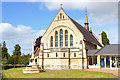
St Andrews Church
Churchdown - St Andrews Church.
Image: © Wayland Smith
Taken: 31 May 2015
0.05 miles
2
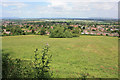
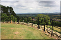
Lower slopes of Churchdown Hill/Chosen Hill
View towards Gloucestershire Airport, over the village of Churchdown with the northern Malvern Hills to the left and Bredon Hill to the right.
Image: © Pauline E
Taken: 3 Jul 2010
0.08 miles
3
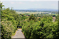
View to Bredon Hill
The single track road approaches the bottom of Churchdown Hill with views over Gloucestershire Airport towards Bredon Hill.
Image: © Pauline E
Taken: 3 Jul 2010
0.09 miles
4
View NNW towards the Malvern Hills
Taken from the lower slopes of Churchdown Hill/Chosen Hill.
Image: © Pauline E
Taken: 3 Jul 2010
0.09 miles
5
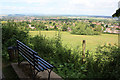
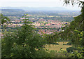
View NNE from Churchdown Hill
Also known as Chosen Hill. The view is across Gloucestershire Airport towards Bredon Hill.
Image: © Pauline E
Taken: 3 Jul 2010
0.14 miles
6
View NNW from Churchdown Hill
Also known as Chosen Hill. The view is towards the Malvern Hills.
Image: © Pauline E
Taken: 3 Jul 2010
0.15 miles
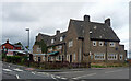
7
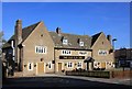
The Old Elm Inn
The former Bat and Ball pub, was completely refurbished in 2015. The photo was taken not long after completion.
Image: © Helen Iwanczuk
Taken: 31 Oct 2015
0.15 miles
8
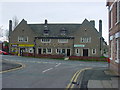
Churchdown - The Bat and Ball Inn
Taken from Chapel Hay Lane. The left hand side of the Inn is now a small supermarket.
Image: © Tony Bailey
Taken: 23 Apr 2006
0.16 miles
9
Churchdown - the old pub
This was the old pub in the centre of Churchdown. If you look carefully you can see the 'new' pub - the Bat and Ball Inn - being constructed in the background. The date is late '40s. See recent photo of The Bat and Ball Inn. http://www.geograph.org.uk/photo/157678
Image: © Tony Bailey
Taken: Unknown
0.16 miles
10
Former pub, Churchdown
It was the Bat and Ball Inn, a 1938-39 rebuilding by L.W. Barnard & Partners.
Happily this pub reopened later the same year Image
Image: © Stephen Richards
Taken: 21 Aug 2015
0.17 miles