IMAGES TAKEN NEAR TO
Lower Meadow, GLOUCESTER, GL2 4YY
Introduction
This page details the photographs taken nearby to Lower Meadow, GL2 4YY by members of the Geograph project.
The Geograph project started in 2005 with the aim of publishing, organising and preserving representative images for every square kilometre of Great Britain, Ireland and the Isle of Man.

There are currently over 7.5m images from over14,400 individuals and you can help contribute to the project by visiting https://www.geograph.org.uk
Image Map
Images are licensed for reuse under creativecommons.org/licenses/by-sa/2.0
Notes
- Clicking on the map will re-center to the selected point.
- The higher the marker number, the further away the image location is from the centre of the postcode.
Image Listing (53 Images Found)
Images are licensed for reuse under creativecommons.org/licenses/by-sa/2.0
Image
Details
Distance
1
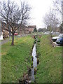
Watermeadows Quedgeley
Watermeadows is the Street name, the stream forms the district boundary with Hardwick in Stroud District to the left and Quedgeley in Gloucester to the right. This bit of Harwick can only be approached through Gloucester.
Image: © Peter Watkins
Taken: 3 Feb 2006
0.11 miles
2
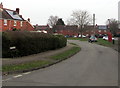
Hildyard Close, Hardwicke
Cul-de-sac viewed from Elmgrove Road East.
Image: © Jaggery
Taken: 22 Jan 2017
0.12 miles
3
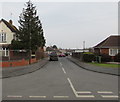
Springfield, Hardwicke
Springfield is a cul-de-sac extending for 300 metres from Elmgrove Road East. A red phonebox is on the right.
Image: © Jaggery
Taken: 22 Jan 2017
0.13 miles
4
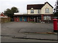
Little Monsters Childcare, Hardwicke
Little Monsters Childcare is at 38 Elmgrove Road East, viewed in January 2017.
An October 2012 Google Earth Street View shows a Nisa Local convenience store (with a post office inside)
on this site. The village post office is now in this http://www.geograph.org.uk/photo/5261114 nearby One Stop convenience store.
Image: © Jaggery
Taken: 22 Jan 2017
0.14 miles
5
Quedgeley boundary sign in a hedge
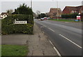
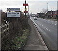
Alongside the B4008 Bristol Road at the southern edge of Quedgeley, a suburb of the city of Gloucester.
The sign faces the northern edge of the village of Hardwicke in Stroud District, Gloucestershire.
The distant parked cars are at the edge of Quedgeley Methodist Church. http://www.geograph.org.uk/photo/5260612
Image: © Jaggery
Taken: 22 Jan 2017
0.14 miles
6
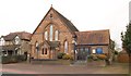
Quedgeley Methodist Church
The church faces Bristol Road. The blue panel states "established 1885".
Image: © Derek Harper
Taken: 12 Mar 2010
0.14 miles
7
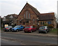
Quedgeley Methodist Church
Viewed across the B4008 Bristol Road. Quedgeley Methodist Church is part of the Gloucestershire Circuit of the Methodist Church. The church is at the southern edge of Quedgeley, near the Hardwicke boundary.
Image: © Jaggery
Taken: 22 Jan 2017
0.14 miles
8
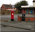
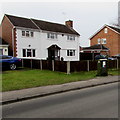
King George VI pillarbox and a litter bin on a Hardwicke corner
On the corner of Elmgrove Road East and Hildyard Close.
Little Monsters Childcare http://www.geograph.org.uk/photo/5261178 is in the background.
Image: © Jaggery
Taken: 22 Jan 2017
0.15 miles
9
Northern boundary of Hardwicke village and Stroud District, Gloucestershire
The signs alongside the B4008 Bristol Road face Quedgeley, a southern suburb of the city of Gloucester.
Image: © Jaggery
Taken: 22 Jan 2017
0.15 miles
10
Telecoms cabinet, Elmgrove Road East, Hardwicke
Viewed in January 2017. This has been a fibre broadband cabinet for several years.
Image: © Jaggery
Taken: 22 Jan 2017
0.16 miles